


Holy Land – Tabula Terre Sanctae
by
Lorenz Fries (after Martin Waldseemüller)
Detail
Date of first edition: 1522
Date of this map: 1535
Dimensions (not including margins): 24,5 (28 cm with garland) x 42 cm
Dimensions (including margins): 39,2 x 54 cm
Condition: Very good and sharp wood cut map. Strong paper and wide margins. Handwriting at top centre ‘oriens’ and at bottom centre ‘occidens’
Condition rating: A
Verso: text in Latin
From: Opus Geographiae by M. Servetus (editor) and M. and G. Trechsel (publishers). Karrow 28/43; Laor 612
Price (without VAT, possibly to be added): €1 800,00 (FYI +/- $1 998,00 / £1 602,00)
Unless otherwise specifically stated on this map page, we charge the following expedition costs in euro (unfortunatelly, gone up with Covid, but still too low in reality!):
– Benelux: 40 euro
– Rest of Europe: 60 euro
– Rest of the World: 100 euro
In stock
Related items
You may also be interested in:

Algiers – Algerii Saracenaorum Urbis Fortissimae…
by
Georg Braun and Frans Hogenberg
Price (without VAT, possibly to be added): €800,00 / $888,00 / £712,00

Scotland – Nova Scotia
by
Willem and Joan Blaeu
Price (without VAT, possibly to be added): €1 000,00 / $1 110,00 / £890,00
A nice map of Scotland

[Untitled] Japan
by
Benedetto Bordone
Price (without VAT, possibly to be added): €2 800,00 / $3 108,00 / £2 492,00
Very rare: oldest map of Japan, and … based on Polo’s description

Toledo (Castile) – Toletum
by
Georg Braun and Frans Hogenberg
Price (without VAT, possibly to be added): €1 500,00 / $1 665,00 / £1 335,00
A map full of history
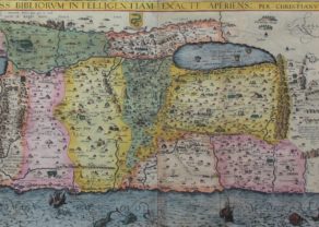
Fries map, which is based upon Waldseemuller’s interpretation of the map which was first published in 1513, is the first example of this projection which is reasonably obtainable for most collectors. The map was published with small changes to the title and verso in 1522, 1525, 1535 and 1541. The first two editions are very rare on the market,
This Ptolemaic Tabula Terre Sanctae (edited by M. Servetus and published by M. and G. Trechsel, 1535, Lyon), was printed from the 1522 woodblocks from the first Fries edition. It is a sized reduced copy of the Waldseemuller maps from 1513. The map is a quasi-copy of it that goes back to the map of Peter Vesconte. Vesconte map of the Holy Land was published by Marina Santuno in ca. 1320 in his Liber Secratorum Fidelibus de Crucis. As noted by Nebenzahl, the Sanuto-Vesconte map ” was destined to provide the basic image of the Holy Land until the eighteenth century.”
Vesconte had taken some mistakes from pilgrim Buchardus of Sion, including the illustration of River Cison from Lake Galilee goes to the Mediterranean. Fries just copied them. Later the same error was copied by of Adrichem, Claes Janszoon Visscher, Cornelius Danckaerts II and others.
Bottom right: Fries showed the correct angle of some 90° towards the Nile Delta to the west. In many more recent maps the coast (at the location of the Nile) just continued in one strait line (see van Adrichem).
As usual, one notices the division of the Holy Land on the basis of the tribes of Israel and the location of Sodom. Rivers (e.g. Jordan River), lakes (e.g. the Dead Sea)and mountain ranges are reasonably well depicted.