Menu
The Leo Belgicus map
It is well-known that the ‘Leo’ maps are a symbol of strength and bravery in their heraldic representation. The series of Leo-maps should be placed in the context of the Eighty Years’ War or “Dutch War of Independence” (1566-1648). They symbolized the revolt of the Seven United Provinces of the Netherlands against the Spanish (Habsburg) Empire.
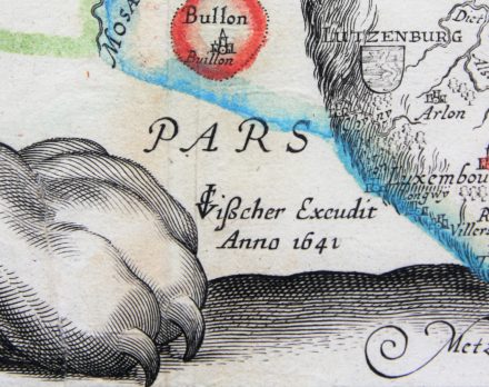
1641
The year of 1641 marked a turning point in the “Dutch War of Independence”. On July 27th 1641, Frederick Hendrik captured the town of Gennep in the provence of Geldern.
In the same year general peace negotiations were initiated in the catholic city of Münster, and the prostestant city of Osnabruck, including the main participants in the Thirty Years’ War: France, Sweden, Spain, the Emperor and the Republic. Though not formally recognized as an independent state, the Dutch republic was for the first time allowed to participate in these peace negotiations.
Genesis of this map: C.J. Visscher excudit anno 1641
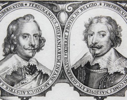
So far, three states of this map were known: 1598, 1630 and 1650. It was widely considered that the 1650 map was the first one with the portraits of Archduke Ferdinand (Governor 1634-1641) and Prince Frederik Hendrik of Orange (Stadholder 1625-1647).
However, this unique and unrecorded map dates 1641. With the discovery of this example of Visscher’s edition, with the date 1641, it becomes much clearer why CJ. Visscher dated the map 1641 and why he THEN added the medallion portraits to the plate. In 1641 both of them were still alive and much more, they were the key negotiators of the Dutch independence.
Moreover, the text in the cartouches refers to both negotiators as representing their country: Ferdinand for the Spain and Frederik Hendrik for the young republic.
Here are the protagonists of the negotiations. Both had already died in 1650. Ferdinand even in 1641, Frederik Hendrik in 1647. Why would a text on a map in 1650 mention that they currently represent their country?
All about the year 1641, the genesis and the particularities of this extraordinary document, please click below on the map.
It must be seen as THE BIRTH CERTIFICATE OF THE YOUNG REPUBLIC.
Have a look and enjoy!