


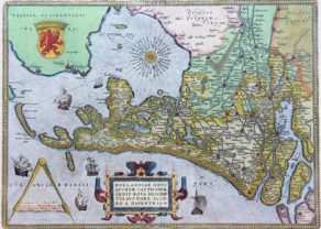
West Friesland and Groningen (North Netherlands) – Frisia Occidentalis
Detail
Date of first edition: 1579
Date of this map: 1595
Dimensions (without margins): 49,3 x 36,6 cm
Dimensions (including margins): 54 x 43 cm
Condition: Excellent engraving on strong paper. Sharp colours.
Condition rating: A+
Verso: text in Latin with coloured initial “F”
Map reference: van der Krogt 3, 3900:31.2; Van den Broecke, 81.2; de Rijke (Friesland), #10.2
From: Theatrum Orbis Terrarum
In stock
West Friesland by Ortelius
This map of West Frisia is based on the manuscript map by Sibrandus Leo. It features excellent detail of the region’s network of waterways. A strapwork cartouche featuring a satyr, a peacock and fruit holds an inset of ancient Friesland from Augustus time. The title appears in a banner cartouche at top.
This sis the second state with “D. Ioachimus Hopperus describebat” added to the inset.
Related items
You may also be interested in:

Chester – Cestria vulgo Chester, Angliae Civitas

Lucca

Avignon
Papal city²

[Untitled] Japan
Very rare: oldest map of Japan, and … based on Polo’s description