
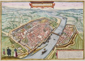
Regensburg – Ratisbona
Detail
Date of first edition: 1596
Date of this map: 1598 (date on the map: 1594)
Dimensions (not including margins): 35 x 49 cm
Condition: Excellent. Strong image with lovely old original colours and wide margins. On heavy paper. Centre fold as published.
Condition rating: A+
Verso: text in Latin
Map reference: Taschen, Br. Hog., p. 403; Van der Krogt 4, 3540
From: Urbium Praecipuarum Mundi Theatrum Quintum Auctore Georgio Braunio Agrippinate. Part 5. Köln, 1596/97. Van der Krogt 4, 41:1.5
In stock
Description
Engraved by J. Hoefnagel in 1594 and dedicated to Emperor Rudolph II.
COMMENTARY BY BRAUN (on verso): “There is also a world-famous stone bridge to be seen in Regensburg, which was built of very large dressed stones and which links the city with the suburb […]. It is said that the bridge and Regensburg cathedral were built at the same time, but by two architects of different abilities, who strove to outdo each other […]. Regensburg has very well-built private and public buildings, and also churches; this can be seen particularly clearly in the case of the great cathedral.”
This engraving emphasizes the political and economic significance of the Free Imperial City of Regensburg. The city is viewed from the north, from a hilltop, looking across a wide stretch of countryside in the foreground, the suburb of Stadt am Hof and the two Islands of Upper and Lower Wörth in the Danube. The cathedral (H) rises above the sea of houses and the city’s other churches. The draughtsman has included himself in the right-hand foreground and has signed and dated his work. Regensburg retains much of its medieval character even today and the mostly narrow, crooked streets of its Old Town still evoke a 16th-century atmosphere. The city’s political importance increased from 1663, when Regensburg was chosen as the permanent location of the imperial diet, which had already convened in the city on several occasions in the 15th century. (Taschen)
Braun and Hogenberg have placed another illustration of Regensburg in their atlas, i.e. in the first book. That view shares one page with perspectives of München, Inglostadt, Freising, Nördlingen, and Straubing.
Related items
You may also be interested in:

Asia Secunda pars Terrae in Forma Pegasi

Lucca

Antequera (Andalusia)
