Menu
ORTELIUS’S PEUTINGER MAPS
Date: 03/03/2023
I ) THE ORIGIN
According Meurer the Tabula Peutingeriana or Peutinger map would be a copy of a Roman travel map from the third, fourth or fifth century. Here is the speculation:
In 1265 a Monk, in the German city of Colmar produced a hand written map, on parchment, of the imperial highways and cities of the ancient Roman world. When joined, the result was a scroll measuring 6.75m long & 34cm wide, covering an area from southeast England to present day Sri-Lanka. That map of 1265 was copied from an earlier 4th or 5th century map, itself copied from a 2nd century map that originated from a 1st century BC map from Marcus Vipsanius Agrippa, a Roman General & architect. When Agrippa died in 12BC his map was engraved in marble and displayed in the Porticus Vipsania in the Campus Agrippae area in Rome.
Centuries later, however, a parchment Tabula Peutingeriana was found. This map is now referred to as the original Peutinger map. The map may have been made by a monk of Colmar and was discovered by Konrad Celtis in a library in southern Germany around 1507. He passed it Konrad Peutinger of Augsburg. So, the name of the map simply refers to a temporarily possessor in the early 16th century. Ortelius understood the importance of the card and contacted the descendants of Konrad Peutinger. In 1597 he received a copy of the map made by Marcus Welser (1558-1614).
The (original) however Peutinger Map got lost and only re-appeared in 1714. In 1720 the map was bought by Prince Eugene of Savoy. After his death his entire collection of maps and books was sold to the imperial library in 1737, the predecessor of the National Library in Vienna, where the map is still kept.
However, the (original) Peutinger Map got lost and only re-appeared in 1714. In 1720 the map was bought by Prince Eugene of Savoy. After his death his entire collection of maps and books was sold to the imperial library in 1737, the predecessor of the National Library in Vienna, where the map is still kept.
II) THE ORIGINAL MAP
The Tabula Peutingeriana covering Britain, Spain and North Africa in the west to the Ganges River in the east. It was originally composed of twelve sheets of approximately 38 cm x 59 to 65 cm and had a total length of 6,82 m. The first sheet with the Iberian Peninsula and the British Isles got lost. One should not look for a realistic representation of the world, since it presents schematic view of the road network and the stage places in the Roman Empire. There is no unanimity on the measures: some distances are shown in Roman miles (milia passuum, about 1.5 km), other distances are in Gallic leuga (about 2,200 meters). So, most likely the map had several sources. One of them may have been the third-century Itinerarium Antonini, which lists approximately 3.500 stage locations with distances.
III) INTERPRETATION BY ORTELIUS AND HIS SUCCESSORS
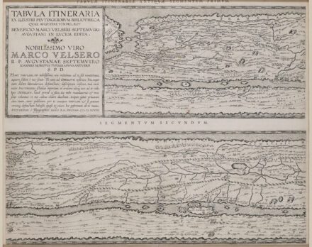
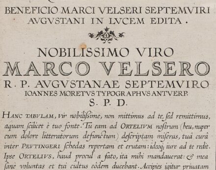
As early as 1577 Abraham Ortelius, the Flemish cartographer, was aware of the existence of the Peutinger Tables, at that stage owned by Mark Welser. In 1591 Welser had two sections of the scroll printed by Aldus Manutius in Venice. Ortelius thought these inadequate and so commissioned the scroll engraved onto 8 separate plates. Ortelius supervised the engraving of the plates but did not live to see the results. The Peutinger Map led to seven subsequent interpretations. This is the Ortelius / Bertius version, the oldest, most famous and most important. Ortelius, however, died before he finished this job, but six months later in 1599 John Moretus I did so and publisher Plantin published 250 copies, half size and spread over 8 (2 x 4) printing plates. This is the so-called editio princeps. Only in 1619 and in 1624 Bertius Baltazar Moretus I will re-use the same plates. Six other editions will follow, from which the version of Johannes Janssonius of 1652 is the most famous. Today, the most frequently used copy of the map is the facsimile of Konrad Miller in 1887. Miller produced a full-color copy of two-thirds of the original size. He thereby recreated the first sheet again and made a hypothetical reconstruction; so Spain, Portugal and England reappeared on the map. The original Peutinger Map (with the addition by Miller) can be consulted online at the Bibliotheca Augustana website. The original version kept in Vienna is not open to the public.
IV) A CLOSER LOOK
It is not so easy to connect all (Roman) names of contemporary cities to connect; it still gives rise to new interpretations. One notices The following localities to:
• Part I: Tournai, Nijmegen, Paris, Tongeren and Cologne
• Part II: Corsica, Sardinia, Lucca, Pisa and Milan
• Part III: Florence, Siena, Verona and Ravenna
• Part IV: Rome with Portus, precisely opposite Cartago, and Sicily
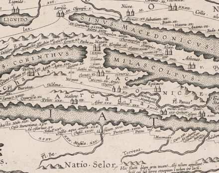
• Part V: Greece with the Peloponnese and Athens
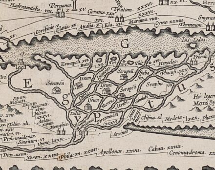
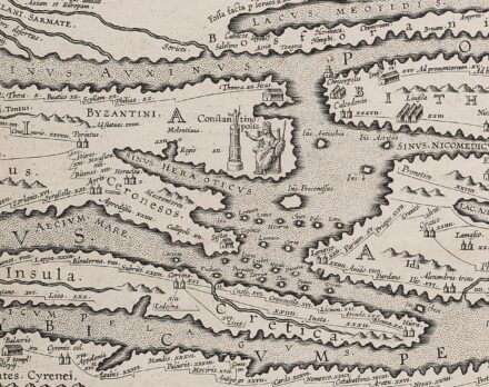
• Part VI: Crete, Constantinopel, Nicea, Pergamon, and the Nile Delta
• Part VII: Jerusalem with the Mons Oliveti, Rhodes, Cyprus, Damascus and Antioch
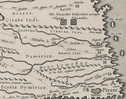
• Part VIII: India to the Ganges with landmarks and delightful references: In these regions, the scorpions are born and in these areas the elephants are born. Right down at the end of the world: Pirate!