


China Hondius/Janssonius
Detail
Date of first edition: 1606
Date of this map: 1633 (Johannes Janssonius and/or Henricus Hondius
Dimensions (not including margins): 34 x 46 cm
Dimensions (inclding margins): 44,4 x 55,8 cm
Condition: Very good. Centre fold as published. Usual slight age-toning. Wide margins. Strange previous professional repair in margins of bottom right corner. Few traces of previous framing at verso.
Condition rating: A+
Verso: text in German
Map reference: Van der Krogt I, 8410:1A; “Imagining China: the View from Europe, 1500–1700,” Folgerpedia: Folger Shakespeare Library, last modified July 10, 2015, accessed September 7, 2019, https://folgerpedia.folger.edu/Imagining_China:_the_View_from_Europe,_1500-1700; Kenneth Nebenzahl, Mapping the Silk Road and beyond:2,000 Years of Exploring the East, (London; New York: Phaidon, 2004), maps 4.6 and 4.7. ACA.
From: Gerardi Mercatoris et I. Hondii Atlas. Van der Krogt I, 1:321/22
In stock
On the Atlas
The first German language edition of the Atlas is a rather complicated edition. There are two different titles, Atlas (1:321) and Atlas Novus (1:322), both with imprints by Janssonius and Hondius or either of these separately. Furthermore 14 maps were replaced during this edition. (Van der Krogt II, page 165)
Related items
You may also be interested in:

Luxembourg, Duchy

[Untitled] Japan
Very rare: oldest map of Japan, and … based on Polo’s description

Bristol – Brightstowe, Vulgo; Quondam Venta, Florentissimum

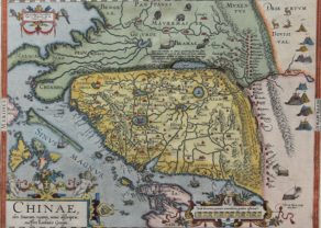
On Hondius’ China
This map, prepared by Jodocus Hondius and Cornelis Claesz, was first published in the Mercator-Hondius Atlas from 1606. It was so successful, that it remained in the atlas until its French edition of 1658 (the Atlas Novus). This copy comes from the German edition of the Mercator-Hondius-Janssonius atlas in 1633.
The borders of China are those of the later years of the Ming Dynasty (1368-1644). The Great Wall of China limits the north and bends in the west straight south to walk into contemporary Thailand. The area of Ming China, now referred to in English as “China Proper”, comprises about half of today’s China. The waterways stand out immediately.
East of China in India extra Gangem lies again the big illusory lake Chimai Lacus.
The visual appeal of this map is further enhanced by a Japanese junk, used as an ocean vessel from the second century BC. As ever in these early maps seamonsters stalk unwary ships and Hondius/Janssonius shows a Dutch merchant sailing on what is labeled as “Chinensis Oceanus“.
A gruesome scene is shown at the right: the crucifixion of Japanese Christians. This probably refers to the crucifixion scene of the 26 Catholics in Nagasaki on February 5, 1597. Unlike the aforementioned older maps this one names many locations.
On Korea
East of China are the islands of Korea and Japan. Korea is depicted as an island, but the accompanying annotation questions whether it is insular or connected to the main continent. The Portuguese were the first Europeans to gain firsthand knowledge of Far East Asia in the sixteenth century, and Portuguese mapmaker Luis Teixera’s map of Japan with Korea as an island was a popular source of information on the geography of the region in the early seventeenth century, influencing what the rest of Europe believed. It is assumed that early European navigators in the region encountered the Yalu River, separating Korea from China, and thought it to be a strait between the Yellow Sea and Sea of Japan.
On America
Popular on maps of this era, the mythical Strait of Anian appears between Asia and North America. Anian derives from Ania, a Chinese province on a large gulf mentioned in Marco Polo’s travels (ch. 5, book 3). The gulf Polo described was actually the Gulf of Tonkin, but the province’s description was transposed from Vietnam to the northwest coast of North America. It became common as a shorthand for a passage to China, i.e. a Northwest Passage. It appeared on maps until the mid-eighteenth century.
It is notable that several place names appear in North America, including Cape Fortuna, Anconde Island, Costa de los Tacbaios, Costa Brava and Alcones. The annotation in North America references the indigenous inhabitants as Tartars. A stag and fox can be seen roaming across the open land beyond the coast.