


Holy Land (part of) – Tribus Zablon, Ischar et diminia Manasse
by
Christiaan van Adrichem
Detail
Date of first edition: 1590
Date of this map: 1602
Dimensions (not including margins): 36,2 x 40 cm
Dimensions (includingmargins): 40 x 47,2 cm
Condition: Very good. Strong paper and wide margins.
Condition rating: A
Verso: blank
Price (without VAT, possibly to be added): €600,00 (FYI +/- $666,00 / £534,00)
Unless otherwise specifically stated on this map page, we charge the following expedition costs in euro (unfortunatelly, gone up with Covid, but still too low in reality!):
– Benelux: 40 euro
– Rest of Europe: 60 euro
– Rest of the World: 100 euro
In stock
Related items
You may also be interested in:

Antequera (Andalusia)
by
Georg Braun and Frans Hogenberg
Price (without VAT, possibly to be added): €475,00 / $527,25 / £422,75

China, Tartary and Japan
by
Lorenz Fries (after Martin Waldseemüller)
Price (without VAT, possibly to be added): €4 000,00 / $4 440,00 / £3 560,00
The first modern map of China printed in Europe

Toledo (Castile) – Toletum
by
Georg Braun and Frans Hogenberg
Price (without VAT, possibly to be added): €1 500,00 / $1 665,00 / £1 335,00

Map of the Moon – Tabula Selenographica in qua Lunarium
by
Johann Gabriel Doppelmayr
Price (without VAT, possibly to be added): €3 500,00 / $3 885,00 / £3 115,00
The unique and famous first comparative chart of the Moon (with double competing nomenclature) from which the names of many lunar features have been derived.
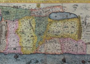
The bible in drawings
This is one of the 10 smaller maps with van Adrichem published in his work. It shows in detail the regions of three tribes: Zebulun, Isschar and Manasseh. On the coast one notices Acco, Mount Carmel (Albert Avogadro (1150-1214) wrote the Order rules for the Carmelites who lived on this mountain) and Caesarea.
Curiously, van Adrichem draws a river between the Sea of Galilee (which lies at an altitude of -212 meters) and the Mediterranean Sea. The depiction of this river goes back a long time in Westeeuropean thinking (see map Fries).
Completely in the northeast corner of the lake lies Capernaum, where Jesus lived for a while. A little further his apostles gather around a boat.
Van Adrichem shows us some other miracles like the food multiplication (see the north side Bethsaida) and Jesus walking over water revolves around this lake.
On the west side of the lake lie Magdalum (possibly the residence of Mary Magdalene) and Tebierias. River Jordan flows towards the Dead Sea. On Mount Tabor, no. 94, the wonder of the transfiguration took place.