
[Untitled] Edo/Tokyo
by
Kikakudo (printer)
Rare and extraordinary Japanese woodcut
Detail
Date of this map: 1861
Dimensions (not including margins): 68 x 95 cm (+ outset)
Condition: Woodcut print on fragile Japanese paper
Condition rating: fragile paper: B+; else A
Verso: blanc
Price (without VAT, possibly to be added): €3 500,00 (FYI +/- $3 885,00 / £3 115,00)
Unless otherwise specifically stated on this map page, we charge the following expedition costs in euro (unfortunatelly, gone up with Covid, but still too low in reality!):
– Benelux: 40 euro
– Rest of Europe: 60 euro
– Rest of the World: 100 euro
In stock
Related items
You may also be interested in:

The Eastern Hemisphere – Hemisphaerium Orbis Antiqui
by
Andreas Cellarius, Johannes Janssonius
Price (without VAT, possibly to be added): €2 800,00 / $3 108,00 / £2 492,00

Michiel de Ruyter, a super collection by Stoopendaal
by
Daniël Stoopendaal
Maybe the greatest admiral of all times

Lucca
by
Georg Braun and Frans Hogenberg
Price (without VAT, possibly to be added): €700,00 / $777,00 / £623,00

Luxembourg, Duchy
by
Abraham Ortelius
Price (without VAT, possibly to be added): €750,00 / $832,50 / £667,50
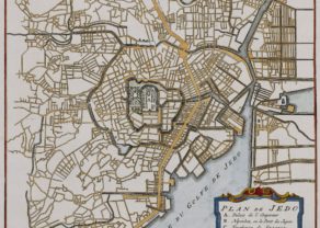
1861, still shogun time for 7 years
Since 794 Kyoto held the seat of the imperial court. However, tensions between the emperor and the high military were never far off. In fact for seven centuries, the feudal military dictator, the shogun, governed the country. The last clan, the Tokugawa shogunate ruled from Edo Castle between 1600 and 1868. In that year emperor Meiji restored his power. And so, Edo became Tokyo when the emperor moved his court to the new capital.
This colorful and highly detailed woodcut map of Edo, or Tokyo shows streets, docks, waterways and bridges. It is centered on the castle of the shogun and Asakusa Sensoji (Tokyo’s oldest temple) and identifies many other buildings, temples, and shrines. With no specific directional orientation, the map and text within seem to radiate around the castle. Even the trees appear upside-down or sideways when the map is viewed from one angle. The map is adorned by two traditional sailing boats occupying the Sumida River.
After the revolution the Emperor built his palace on the same spot.
…
This map was personally purchased a few years ago in the old antiquarian book quarter in Tokyo, while on holiday in Japan,