


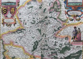
Limbourg (Limburg) – Limburgenses Ducatus…
by
Petrus Kaerius
With inset of the city of Limbourg
Detail
Date of first edition: 1617
Date of this edition: 1617
Dimensions (not including margins): 37,5 x 49 cm
Dimensions (including margins): 40,4 x 55 cm
Condition: Mint. Sharp copper engraving printed on paper. Centre fold as published. Superb old colouring.
Condition rating: A+
Verso: text in Latin
Map reference: van der Krogt III, 3170:364
From: Petri Kaerii Germania Inferior id est, XVII Provinciarum ejus novae et exactae Tabulae Geographicae, cum Luculentis Singularum descriptionibus additis. à Petro Montano. Amsterdam, Pieter van den Keere, 1617. Koeman Kee1; van der Krogt III,64:01
Price (without VAT, possibly to be added): €1 800,00 (FYI +/- $1 998,00 / £1 602,00)
Unless otherwise specifically stated on this map page, we charge the following expedition costs in euro (unfortunatelly, gone up with Covid, but still too low in reality!):
– Benelux: 40 euro
– Rest of Europe: 60 euro
– Rest of the World: 100 euro
In stock
Related items
You may also be interested in:

[Untitled] Japan
by
Benedetto Bordone
Price (without VAT, possibly to be added): €2 800,00 / $3 108,00 / £2 492,00
Very rare: oldest map of Japan, and … based on Polo’s description

San Adrian (Navarre) – La Sierra de Sant Adrian en Biscaia
by
Georg Braun and Frans Hogenberg
Price (without VAT, possibly to be added): €700,00 / $777,00 / £623,00

China, Tartary and Japan
by
Lorenz Fries (after Martin Waldseemüller)
Price (without VAT, possibly to be added): €4 000,00 / $4 440,00 / £3 560,00
The first modern map of China printed in Europe

The Eastern Hemisphere – Hemisphaerium Orbis Antiqui
by
Andreas Cellarius, Johannes Janssonius
Price (without VAT, possibly to be added): €2 800,00 / $3 108,00 / £2 492,00
Petrus Kaerius & the Germania Inferior
Van Den Keere’s atlas of the Low Countries (Germania Inferior) is one of the landmark regional atlases of the early 17th Century, with the maps engraved by himself. The atlas contains the famous Leo Belgicus map. Maps are always embellished with superb cartouches.
He would go on to do significant work for John Speed and a number of other map makers in the first part of the 17th century.
Full title: Limburgenses Ducatus Nova Descriotio Auctore Aegidio Martini Anno 1616