


Middelburg – Middelburgum
by
Joan Blaeu
A jewel to visit
Detail
Date of first edition: 1649
Date of this edition: 1652
Dimensions (not including margins): 46,5 x 57 cm
Dimensions (including margin): 54,5 x 64,5 cm
Condition: excellent. Sharp copper printing on paper. Centre fold is as published. Superb old hand coloured. Wide margins.
Condition rating: A+
Verso: text in Latin
Reference: Van der Krogt IV, 2740
From: Novum Ac Magnum Theatrum Urbinum Belgicae Liberae Ac Foederatae, Amsterdam, 1649. Van de Krogt IV, 43:121, page iij A
Price (without VAT, possibly to be added): €900,00 (FYI +/- $999,00 / £801,00)
Unless otherwise specifically stated on this map page, we charge the following expedition costs in euro (unfortunatelly, gone up with Covid, but still too low in reality!):
– Benelux: 40 euro
– Rest of Europe: 60 euro
– Rest of the World: 100 euro
In stock
Related items
-
[Untitled] Walcheren in Zeeland
by Nicolaes VisscherPrice (without VAT, possibly to be added): €1 600,00 / $1 776,00 / £1 424,00Visit Walcheren!
-
Middelburg, second VOC home base
by Mattheus SmallegangePrice (without VAT, possibly to be added): €650,00 / $721,50 / £578,50A unique triplet from the VOC’s second home base
-
Vlissingen (Flushing)
by Joan BlaeuPrice (without VAT, possibly to be added): €800,00 / $888,00 / £712,00ON HOLD -

Veere – Vere
by Ludovico GuicciardiniPrice (without VAT, possibly to be added): €420,00 / $466,20 / £373,80
You may also be interested in:

Cuzco (Inca capital)
by
Giovanni Battista Ramusio
Price (without VAT, possibly to be added): €850,00 / $943,50 / £756,50
Rare first edition (block destroyed by fire)

Michiel de Ruyter, a super collection by Stoopendaal
by
Daniël Stoopendaal
Maybe the greatest admiral of all times

Lucca
by
Georg Braun and Frans Hogenberg
Price (without VAT, possibly to be added): €700,00 / $777,00 / £623,00

Lisbon
by
Georg Braun and Frans Hogenberg
Price (without VAT, possibly to be added): €1 300,00 / $1 443,00 / £1 157,00
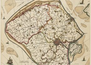
Blaeu’s Middelburg, a visit in time
One of our absolute favored small towns in Northwestern Europe is Middelburg, Zeeland. On top this very rare jewel is, in our opinion, by far, the most beautiful and a unique map of the city.
During the Middle Ages Middelburg was connected to open sea through a difficultly navigable tidal creek, the Arne. In 1530 Charles V granted permission to the city to straighten a navigable waterway, the channel of Welzinge (bottom map; don’t be mistaken, currently, this is the dual carriage way entering the city from the highway). The construction of the channel would become the starting point of the rise of the town. In 1540 Charles V gave permission to construct a new inland port. In the last quarter of the 16th century the population rose by 25%, from about 7.000 to 10.000 people. In defence of this channel fortress Rammekens would be built in 1547.
On the large empty market place once stood the Westmonsterkerk (still present on the map of Braun-Hogenberg). In 1574 Middelburg was conquered by the Geuzen and the next year it was decided to demolish the ruined church. Hence the large open space, with the town hall on one side. Centrally on the map lies the Premonstratensian Abbey, founded in 1127 by monks of the St Michael’s Abbey in Antwerp. After the surrender and despite religious guarantees by William of Orange this Catholic Abbey was closed and taken over by secular authorities. A part of the buildings now houses the Zeelandmuseum, which owns a beautiful collection of large tapestries on the Eighty Year’s War. The Nieuwe Kerk and the Koorkerk, each situated on one side of the tower the Lange Jan, were part of the abbey complex.
In 1603 the Korendijk (see inner parallel waterway) got protected by a lock: It was the first tidal dock built in the United Provinces, to be used as a yard of the VOC, Chamber Zeeland.
Middelburg would become the most important city of the Republic (after Amsterdam), lasting to the final decades of the 17th century. To better understand the importance of Middelburg, please consider the following: The Dutch East India Company (the VOC) was governed by 17 gentlemen (the Heeren XVII). Amsterdam was entitled to 8 seats, Zeeland to 4, and each of Delft, Hoorn, Enkhuizen and Rotterdam had one seat. The 17th seat rotated amongst all small cities. The four seats of Chamber Zeeland were distributed between Middelburg (3) and tiny charming Veere (1). Approximately ¼ of the VOC vessels were built in Middelburg. For reasons of draught VOC vessels did not dock near the city, but loaded and unloaded at Rammekens.
For more information on the presence of the VOC in Middelburg, go to our view 52004!
Top left a pinch of nostalgia: the weapon (with Crown!) of the County of Zeeland, although since its signature of Plakkaat van Verlatinghe (Act of Abjuration) Zeeland ceased to be an County. The coat of arms of Middelburg (right) shows a yellow double Tower on red background.