
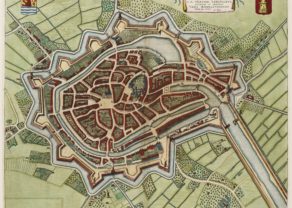
[Untitled] Walcheren in Zeeland
by
Nicolaes Visscher
Detail
Date of first edition: 1655
Date of this edition: 1670
Dimensions (not including margins): 46,5 x 53,5 cm
Condition: excellent. Sharp copper engraving printed on paper. Wide margins. Nice old outline colouring. Wall map!
Condition rating: A+
From: Nicolaes Visscher, Amsterdam
Reference: Blonk & Blonk-van er Wijst, Zelandia Comitatus, Walcheren 3 (2nd state)
Price (without VAT, possibly to be added): €1 600,00 (FYI +/- $1 776,00 / £1 424,00)
Unless otherwise specifically stated on this map page, we charge the following expedition costs in euro (unfortunatelly, gone up with Covid, but still too low in reality!):
– Benelux: 40 euro
– Rest of Europe: 60 euro
– Rest of the World: 100 euro
In stock
Not an atlas map, but one section of a nine part wall map!
Related items
-
Middelburg – Middelburgum
by Joan BlaeuPrice (without VAT, possibly to be added): €900,00 / $999,00 / £801,00A jewel to visit
-

Veere – Vere
by Ludovico GuicciardiniPrice (without VAT, possibly to be added): €420,00 / $466,20 / £373,80 -
Middelburg, second VOC home base
by Mattheus SmallegangePrice (without VAT, possibly to be added): €650,00 / $721,50 / £578,50A unique triplet from the VOC’s second home base
You may also be interested in:

Toledo (Castile) – Toletum
by
Georg Braun and Frans Hogenberg
Price (without VAT, possibly to be added): €1 500,00 / $1 665,00 / £1 335,00

Achaia, Attica and Gulf of Corinth
by
Johannes Janssonius
Price (without VAT, possibly to be added): €450,00 / $499,50 / £400,50

Bristol – Brightstowe, Vulgo; Quondam Venta, Florentissimum
by
Georg Braun and Frans Hogenberg
Price (without VAT, possibly to be added): €900,00 / $999,00 / £801,00

[Untitled] Japan
by
Benedetto Bordone
Price (without VAT, possibly to be added): €2 800,00 / $3 108,00 / £2 492,00
Very rare: oldest map of Japan, and … based on Polo’s description
Visscher’s Walcheren, an ideal holiday destination
An excellent weekend trip from any place in Belgium/the Netherlands: the old isle of Walcheren
In the dunes northeast of Domburg lay in the 8th century the trade and port of “Walichrum”, hence the name of the island. On the beach of the Domburg Visscher referred to the “Temple of Nehalennia” (2nd century: a remnant of the temple is an altar dedicated to this goddess, currently at display in the national museum of Antiquities in Leiden). In the period which followed the discovery of this site in 1647, the local beach and its dunes, were swallowed up by water.
Regent or governor (and sister of Charles V) Mary of Hungary had already ordered in 1547 the building of a fortress in the strategically environment of Rammekens (just outside Vlissingen or Flushing). The capture of Fort Rammekens in 1574 by the “Geuzen”, also predated the coming fall of Middelburg in Much later… and in exchange for her sending of an expedition corps of about 6.000 men in 1585 in support of the Revolution, Queen Elisabeth I received, inter alia, the transfer to English Crown of places such as Rammekens, Brielle, Ostend (which explains why Queen Elisabeth for a period of 30 years.
In the 2nd half of the 17th century many maps were made of Walcheren. All of the old maps on Walcheren are based on the 9-piece wall map of N. Visscher and Zacharias Novel from 1655. This singular section by N. Visscher shows the four “wateringen” of Walcheren, with separate colorization. Already at the end of the 12th century an intercity cooperation started with respect to dike protection and drainage. Later this system was institutionalized with the East, the West, the South “Wateringhe” and the five Crafts (“Ambachten” around Domburg).
A 7 km long straight road between Veere and Middelburg was also built. In 1693 the town governors of Middelburg and Veere ordened the following road regulation of which article 24 says: “De wagens malkanderen ontmoetende sullen behoorlijk moeten uijthalen. Een ventwagen voor een karosse, heerenwagen en gelaaden wagen. En sal de wagen die voorbij half wegen is gereeden regt door rijden en dan die moeten ruijmen en uijthaalen near de suijtoostzijde.” The beautiful town of Veere is now closed from the sea: the “Veerse meer” has become an excellent and relatively quiet sailing resort.
Beautifully exposed are also the various courts and castles. Southeast of Middelburg is located the early reclaimed area: in 1633 the “opwas” was diked, followed by the “Sint-Joosland” polder in 1644. The village at the left, where the red line departures from the coast, is called “Soutelande”…
As mentioned before, this map is actually a/one section of a much larger wall map: 1 out of 9 parts Dutch Zeeland by Visscher. More recent versions of this part were produced by Joan Blaeu (in the Atlas Maior) and by Ottens.
Unfortunately… as history goes: the towns of Middelburg and Flushing (Vlissingen) have now grown into one big agglomeration.
For your trip to Zeeland you should also also visit: