


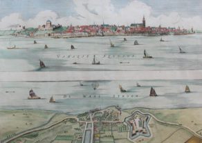
Nijmegen – Nieumegen
Detail
Date of first edition: 1639
Date of this edition: contradicting information in van der Krogt: date is not identifiable; probably third state
Dimensions (not including margins): 38 x 41,8 cm
Dimensions (including margins): 48,7 x 60 cm
Condition: excellent. Sharp copper engraving printed on paper. Old coloured. Centre fold as published. Wide margins.
Condition rating: A+
Verso: text in Latin
Map reference: Van der Krogt IV, 2-2, 3068; Fauser 9920
From: originally Pontianus’ Historiae Gelricae libri XIV, 1639
van Geelkercken and the Nijmegen map
Nicolaes van Geelkercken (ca.1585 – 1656) was a Gelderland surveyor and cartographer who was employed by the Gelderland government in the 17th century.
This map was oriiginally published by Nicolaas van Wieringen in Harderwijk in 1639 and by Johannes Janssonius in Amsterdam in the Historiæ Gelricæ Libri XIV Deducta omnia adea (…), by Johannes Isacius Pontanus.
One notices an extensive legend with 51 items as well as the city arms.
Upright important buildings such as Stevenskerk and Het Valkhof. With construction Bastions.
Note: left bottom mentions “J. van Geelkerck delin”
Knodsenburg (bottom)
Knopdsenburg was initially built as a traditional redoubt with four bastions and a moat by the Dutch rebels in 1585. They wanted to besiege the city of Nijmegen from the other side of the River Waal. The Spanish attacked and chased the Dutch, after which they possessed a strategic place with which they could control the eastern river area. They dismantled the redoubt after a certain period of time. After the recapture in 1590, Maurits van Oranje had the redoubt reinforced and expanded into a fortress, while a kind of redan was built on the city side. Now the fort was taken into use as a base to take Nijmegen. In 1591 the fort was besieged by Parma. It was then fiercely defended by Gerrit de Jong, former commander of Lochem, until they were relieved by Hohenlo. In the 17th century the fort was improved again and it got its star shape with an extra moat. The fort was expanded with an exterior with a glazing around it. In 1672 the French took the fort, from there they could incessantly bombard Nijmegen with their artillery. The fort was decommissioned in 1674. In the 19th century, the fort fell into disrepair. It was sold in 1808 and eventually dismantled.
Taschen on Nijmegen
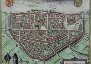
A bird’s-eye view of the city, where the royal castle of Valkhof can be seen on the right within the city walls. In the city centre is the tall Gothic Sint-Stevenskerk. This imperial and Hanseatic city was going through a troubled phase in Braun and Hogenberg’s time. In 1543 Nijmegen, together with Guelders, became Spanish as a result of the Treaty of Venlo. In 1579 the city joined the United Provinces and was besieged and captured in 1585 by the Spanish in the course of the Dutch Revolt. The Orange party did not succeed in recapturing Nijmegen until 1591.
Related items
You may also be interested in:

Toledo (Castile) – Toletum

Veere – Vere

[Untitled] Japan
Very rare: oldest map of Japan, and … based on Polo’s description

Avignon
Papal city²