


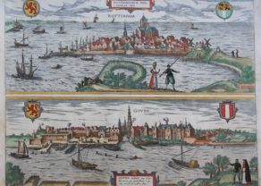
Rotterdam – Roterodamum
Origin of a world class port
Detail
Date of first edition: 1588
Date of this map: 1588 or later
Dimensions (not including margins): 28,5 x 40 cm
Dimensions (including margins): 42 x 55 cm
Condition: very good. Copper engraving on strong paper. Centre fold as published. Old colouring. Very wide margins.
Condition rating: A
Verso: text i French
Map reference: Van der Krogt IV, 2-2, 3773; Taschen, Br. Hog., p. 285
From: Civitates Orbis Terrarum, Urbium praecipuarum totius mundi, liber quartus, first edition 1588. Van der Krogt IV, 2-2, 41:1-3, page 13
In stock
Rotterdam commented by Braun
“Rotterdam is a city in northern Holland that is known far and wide because of the glorious Erasmus of Rotterdam. In the Dutch language it is called Rotterdam, like many other cities in this country with names ending in -dam, such as Amsterdam, Sparendam, Munichendam, Edam, Schedam etc., because they were all built on a dam. Its citizens are wealthy, have a renowned herring fishing industry and conduct trade with foreign countries. For many years they have been inclined towards religious reform and today still adhere to the teaching of Calvin.”
TRANSLATION OF CARTOUCHE TEXT: Rotterdam, at the mouth of the River Roter, home town of the great Desiderius Erasmus.
Taschen on Rotterdam
This is a bird’s-eye view from the west of the city, which is surrounded by a wall erected in 1359. The view is dominated by canals, the mouth of the new Meuse and the tributaries of the Meuse, including the River Rotte, from which the city gets the name. The late Gothic Sint Laurenskerk stands out clearly, and the ocean-going ships are a reference to the city’s role as a trading port. After growing up as a fishing village in the early 13th century, Rotterdam was granted a municipal charter in 1340. Canals to the Schie linked the city with Delft, the most important trade centre at that time, from whose wealth it was able to profit. From 1586 onwards high numbers of refugees from the Spanish Netherlands settled in the city. The most important commercial activities were tapestry and cloth production; at that time the port ranked far behind Amsterdam.
Related items
-
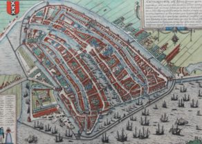
Amsterdam – Amstelredamum
by Georg Braun and Frans HogenbergBefore the great expansion
-
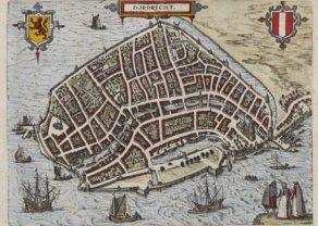
Dordrecht
by Ludovico GuicciardiniPrice (without VAT, possibly to be added): €300,00 / $333,00 / £267,00 -
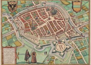
Groningen
by Georg Braun and Frans HogenbergPrice (without VAT, possibly to be added): €650,00 / $721,50 / £578,50 -
Rotterdam & Gouda – Roterodamum Hollandiae opp. / Goude
by Georg Braun and Frans HogenbergPrice (without VAT, possibly to be added): €1 000,00 / $1 110,00 / £890,00
You may also be interested in:

Toledo (Castile) – Toletum

Jan Mayen – Insulae Johannis Mayen Cum universe situ Sinuum et Promontariorum
Rare Spanish edition

Avignon
Papal city²

Rotterdam, then
This map by Jacob van Deventer shows the city named after the dam on the River Rotte (hence Rotter-dam), made more or less at the time of the last years of its most famous resident, Erasmus. The town was only founded around 1260 and remained a relatively small fishing port, as illustrated for a long period by the “recent” data for the town charter and the construction of the wall, respectively in 1340 and 1359. The big river port of the county Holland was Dordrecht. The rival cities of Delft and Dordrecht were, however, destroyed by the St. Elizabeth’s flood in 1421. This contributed to the flourishing of Rotterdam. Around 1573 the city had about 10,000 inhabitants, in 1650 already 50,000. Between 1449 and 1525 was built to the late Gothic Laurenschurch (middle of the view).
The Braun & Hogenberg atlas contains a second view of the city – a half view with Gouda: see n° 32016.