


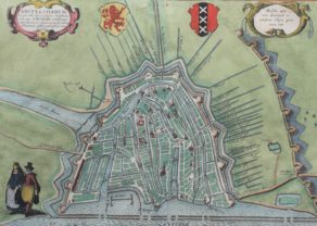
Amsterdam – Amstelredamum
Before the great expansion
Detail
Date of first edition: 1572
Date of this edition: 1612
Dimensions (not including margins): 34 x 49 cm
Dimensions (including margins): 41,3 x 54,3 cm
Condition: very good. Sharp copper engraving printed on paper. Original colouring. Centre fold as published. Wide margins. Light age toning in margins.
Condition rating: A
Map reference: Van der Krogt IV, 107; Fauser 360, Taschen, Br. Hog., p. 76.
From: Civitates Orbis Terrarum, Liber Primus, first published 1572, this edition 1612, Köln
This item is sold
Amsterdam commented by Braun
“Holland is the most fertile part of the Netherlands. It is crossed by many waterways full of fish, which ensure that in the whole world there is no other landscape in which so many cities lie within such a confined area … Amongst these, Amsterdam is the noblest … It lies on the River Amstel, from which many canals lead into the city. About twice a year many ships arrive here from all over Europe, some 200 or 300 from the Netherlands, France, England, Spain, Portugal, Germany, Poland, Lithuania, Norway, Sweden and the other countries of the North. … There are also very good and experienced ship-builders here. … This city is supported on large and sturdy wooden stilts that have been driven into the bed of the water. When you see the air, the sea, the dams and the many sluices, you can easily compare the city with Venice and consider it just as fortunate.”
TRANSLATION OF CARTOUCHE TEXT: Amsterdam is a well-known city in Lower Germany that has arisen in recent times to accommodate merchants and is inhabited by people engaged in trade. It is almost impossible to think of a commercial activity that is not practised here. Hence profit seeking businessmen are drawn to this city from the most far-away lands and transship various goods, first and foremost grain, to Brabant and other parts of the world. Vast riches result from trade of this kind.
Taschen on Amsterdam
The plan presents Amsterdam in bird’s-eye view from a northeasterly direction. On the left-hand side we can see how the mouth of the River Amstel has been dammed and its waters channelled into canals and made to pass through the city before flowing out into the Zuiderzee (today the IJsselmeer). The canals, which were used to transport imported goods to the counting houses located all over the city, are lined with private houses, commercial buildings and warehouses. In the centre of the plan, the old town hall (Stadhuis, 21) and the neighbouring Nieue Kerk (23) are also clearly recognizable. With its depiction of the heavy shipping traffic inside the harbour and on the Zuiderzee, the engraving conveys an impression of the contemporary scale of trade conducted in the continually expanding metropolis. In the 13th century Amsterdam was simply a small fishing port built on marshy ground. In 1300 it was granted its municipal charter and in 1369 became a member of the Hansa. Not until the beginning of the 1600s did the city finally establish itself as the leading centre of trade and the constantly expanding hub of a global financial and commercial empire. This Golden Age brought not only an economic boom but also a flowering of the sciences and arts, which lasted until the end of the 17th century: Between 1570 and 1640 Amsterdam’s population grew from around 30,000 to almost 140,000; today it numbers around 750,000. (Taschen)
Related items
-
Amsterdam (expansion)
by Georg Braun and Frans Hogenberg -
Holland – Hollandiae Antiquorum Catthorum Sedis Nova Descriptio
by Abraham Ortelius -
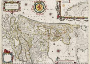
Holland – Hollandia Comitatus
by Willem and Joan BlaeuPrice (without VAT, possibly to be added): €1 350,00 / $1 498,50 / £1 201,50Orientated west to the top of the map. Inset of Frisian or Wadden islands
-
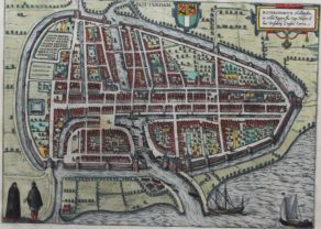
Rotterdam – Roterodamum
by Georg Braun and Frans HogenbergPrice (without VAT, possibly to be added): €840,00 / $932,40 / £747,60Origin of a world class port
You may also be interested in:

Asia Secunda pars Terrae in Forma Pegasi

Cuzco (Inca capital)
Rare first edition (block destroyed by fire)

Jan Mayen – Insulae Johannis Mayen Cum universe situ Sinuum et Promontariorum
Rare Spanish edition

Amsterdam in the 16th century
Made after a woodcut plan of Cornelius Antoniszoon, 1544, this plan shows Amsterdam as it existed in the middle years of the sixteenth century. The engraving depicts that almost uniquely Dutch form of urban site: a river, in this case the Amstel, dammed near its mouth and its flow controlled by channels to the sea with an outer harbour created from the downstream portion – the Damrak – and an inner harbour from the upstream portion – the Rokin. The dykes containing the channels acted as routes for land traffic to and from the warehouses built on the berms. The Dam itself, seen in the centre of the plan, provided a central open space for public buildings such as the old Stadhuis and the church nearby.
When this view was first published in the Civitates in 1572, Amsterdam was beginning to see an increase in trade handled by the port following the effective Spanish destruction of Antwerp by the soldiers of Philip II of Spain in 1576. In 1585 the Spanish definitively conquered Antwerp and by 1600, Amsterdam had assumed the rank once held by its southern rival, handling trade from the Baltic, and southern Europe and from farther afield. By 1600, Amsterdam had thus laid the foundations of what was to become a great trading empire rivaling the other maritime powers of Europe in the East Indies and West Indies alike. The shipping depicted in this engraving, however, give some idea of the commercial bustle of the former fishing hamlet on a dam near the mouth of a small river.