


Wroclaw – Wratislava
by
Georg Braun and Frans Hogenberg
Detail
Date of first edition: 1588
Date of this map: 1588-1597
Dimensions (not including margins): 36,5 x 49 cm
Dimensions (including margins): 42,5 x 56 cm
Condition: Good copper engraving. Old colouring. Strong paper and wide margins. General age-toning (verso) and signs of previous framing (in margins).
Condition rating: A/B
Verso: text in Latin (vvratislavia)
Map reference: Van der Krogt 4, 4876
From: Civitates Orbis Theatrum, Liber quartus Urbium Praecipuarum totius Mundi. Cologne, 1588-97. Taschen Br. Hog., p. 324; Koeman, B&H4; Van der Krogt 4, 41:1-3, page 42
Price (without VAT, possibly to be added): €1 100,00 (FYI +/- $1 221,00 / £979,00)
Unless otherwise specifically stated on this map page, we charge the following expedition costs in euro (unfortunatelly, gone up with Covid, but still too low in reality!):
– Benelux: 40 euro
– Rest of Europe: 60 euro
– Rest of the World: 100 euro
In stock
Related items
You may also be interested in:

Edinburgh
by
Georg Braun and Frans Hogenberg
Price (without VAT, possibly to be added): €1 700,00 / $1 887,00 / £1 513,00

Toledo (Castile) – Toletum
by
Georg Braun and Frans Hogenberg
Price (without VAT, possibly to be added): €1 500,00 / $1 665,00 / £1 335,00

San Adrian (Navarre) – La Sierra de Sant Adrian en Biscaia
by
Georg Braun and Frans Hogenberg
Price (without VAT, possibly to be added): €700,00 / $777,00 / £623,00

Luxembourg, Duchy
by
Abraham Ortelius
Price (without VAT, possibly to be added): €750,00 / $832,50 / £667,50
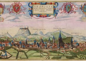
Born, glorified, destroyed and reborn
At the banks of River Oder (flowing from bottom right to top left) Breslau, Germany’s largest city east of Berlin, was located. In the 19th century it was the largest German city, just after Berlin and Hamburg.
Both the German and the Polish names believed to originate from the Bohemian duke Wratislaw I, who ruled the city in the 10th century. After the death of King Boleslaw III in 1138, Breslau was the capital of the Duchy of Silesia. In the middle of the 14th century Silesia became part of Bohemia.
The arms at the top right show the essentials of the city: top left the Bohemian Lion, top right the Eagle Silesia and bottom left the letter “W” which refers to Wratislaw I and also to the city name and state Wratislavia and bottom right a portrait of John the Evangelist. In the middle of the arms is John Baptist watching.
The importance of the city can also be deducted from the large number of large churches. Far right one notices on Cathedral island the Cathedral of St. John the Baptist (with two towers). Central in the city lies the commercial centre: der Rinck (no. 13, the market place), with, inter alia, the town hall (no. 14) and the small weigh house (no. 16).
The civil power center was located in the former ducal castle (no. 30). In 1526 the city came under Habsburg rule and in 1742 the city became Prussian. Breslau was largely destroyed in WWII. After the war the German population got expelled from the city and replaced by Poles coming from the East, where they were expelled themselves (e.g. from Lviv).
Hogenberg’s source for this view was Jacob Moravius.