

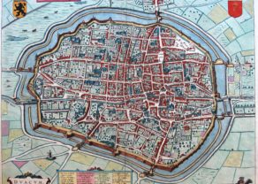
Arras – Atrebatum, Gallis ARRAS Belgice ATRECHT dictu
by
Joan Blaeu
Detail
Date of first edition: 1649
Date of this map: 1649
Dimensions (not including margins): 51 x 40,9 cm
Dimensions (including margins): 57,8 x 47,3 cm
Condition: Very good. Sharp copper engraving on srong paper with wide margins. Centre fold as published.
Condition rating: A
Verso: text in Latin
Map references: Van der Krogt 4, 254; Fauser, 711.
From: Novum Ac Magnum Theatrum Urbium Belgicae. (= “Stedeboeck”) Amsterdam, J. Blaeu, 1649. Van der Krogt 4, 43:111-113
Price (without VAT, possibly to be added): €370,00 (FYI +/- $410,70 / £329,30)
Unless otherwise specifically stated on this map page, we charge the following expedition costs in euro (unfortunatelly, gone up with Covid, but still too low in reality!):
– Benelux: 40 euro
– Rest of Europe: 60 euro
– Rest of the World: 100 euro
In stock
Related items
You may also be interested in:

Edinburgh
by
Georg Braun and Frans Hogenberg
Price (without VAT, possibly to be added): €1 700,00 / $1 887,00 / £1 513,00

Algiers – Algerii Saracenaorum Urbis Fortissimae…
by
Georg Braun and Frans Hogenberg
Price (without VAT, possibly to be added): €800,00 / $888,00 / £712,00

Bristol – Brightstowe, Vulgo; Quondam Venta, Florentissimum
by
Georg Braun and Frans Hogenberg
Price (without VAT, possibly to be added): €900,00 / $999,00 / £801,00

Avignon
by
Georg Braun and Frans Hogenberg
Papal city²
The Union of Arras (Atrecht)
During the Middle Ages, possession of Arras passed to the feudal rulers who controlled the local region: so, its logically passed from County of Flanders over the Duchy of Burgundy to the Spanish branch of the House of the Habsburg.
The Union of Arras was signed here in January 1579 by the Catholic principalities of the Low Countries that remained loyal to King Philip II of Habsburg; it immediately provoked the (opposing) declaration of the Union of Utrecht later the same month.
The provinces that signed the Peace Treaty with Spain were a small minority of the XVII Provinces and included:
Other regions that favored the Arras Peace, but did not sign it at time (though they later acceded), were:
In 1659 the Spanish ceded Arras to the French Crown and it has since remained French.