


Norway, Trondheim
Charting at its best
Detail
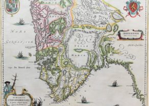
Date of first edition: 1697 – 1709
Date of this map: 1697 – 1709
Dimensions (not including margins): 51,8 x 59
Dimensions (with margins): 53,5 x 60,3 cm
Condition: Very good. Strong laid paper and rather small margins. Watermark “LWP”. Later colouring.
Condition rating: A
Verso: blank
From: De Nieuwe Groote Lichtende Zee-Fakkel, 1697-1709, Chart No. 30, Amsterdam
Map references: Koeman, Keu (45); Ginsberg (Seacharts Norway), 8A.6 (State 3)
In stock
Trondheim
Trondheim (as mentioned on the map in Dutch as “Dronten”) is an old Norwegian city at its coastline. The settlement was founded in 997 as a trading post, and it served as the capital of Norway during the Viking Age until 1217.
Its most famous building is the Nidaros cathedral, built over the burial site of King Olav II (c. 995-1030, reigned 1015-1028), who became the patron saint of the nation, and is the traditional location for the consecration of new kings of Norway. It was built over a 230 year period, from 1070 to 1300.
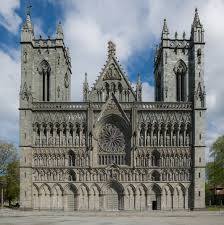
Today, it is the largest municipality of Norway, after Oslo and Bergen.
Related items
You may also be interested in:

Lisbon

Chester – Cestria vulgo Chester, Angliae Civitas

The Eastern Hemisphere – Hemisphaerium Orbis Antiqui

Jan Mayen – Insulae Johannis Mayen Cum universe situ Sinuum et Promontariorum
Rare Spanish edition
Trondheim by van Keulen
Full title: ‘Paskaart van de Kust van Noorwegen Beginnende van Swarten Os tot aan Heyligelander Leen. Naauwkeurig opgestelt, waar in vervaat werdt ‘t Lied van Dronten …’, in a cartouche centre left.
Bottom right another cartouche with two figures showing mile scales.
Orientation: South.
Two compass roses, many rhumb lines, ship at sea.