


Southern Norway – Dioecesis Stavangriensis & partes aliquot vicinae, opera L. Scavenii, S.S
Detail
Date of first edition: 1640 (Appendix by Joan and Cornelis Blaeu)
Date of this map: 1640
Dimensions (not including margins): 41,5 x 50 cm
Dimensions (including margins): 49,3 x 58 c m
Condition: Very good. Strong paper and wide margins. Slight age-toning. Centre fold as published.
Condition rating: A+
Verso: Latin text
Map reference: Van der Krogt 2, 1310:2
From: Appendix; Van der Krogt, 2:10A, page 9 H
In stock
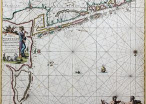
Dioecesis Stavangriensis
Blaeu’s map is his first one to focus on Norway. The map shows the Bishopric of Stavanger and the adjacent regions based upon the work of Laurids Clausen Scavenius, the Bishop of Stavanger from 1605 to 1626. The map locates the major villages and towns and presents reasonable coastal detail. However, the interior topography is not very accurate with Opslo Tellemarck shown as a large empty region, save for a large lake and a notation describing the road from Stavanger to Hallengdal as very hard due to the steepness of the mountains.
The map provides an in-depth view of the fjord system in southern Norway. Standing alone is Oslo fjord. In the West one notices: Stavanger fjord, Hardanger fjord and on top part of Sognefjord.
Prominently present is the white area called Tellemarck. This is Hardangervidda, a mountain plateau with a micro winter climate.
The Mare Germanicum is called “in vulgo”: “De Noord Zee”.
Includes 4 sailing ships, compass rose, 2 cartouches and 2 coat of arms.
Related items
You may also be interested in:

China, Tartary and Japan
The first modern map of China printed in Europe

The Eastern Hemisphere – Hemisphaerium Orbis Antiqui

Algiers – Algerii Saracenaorum Urbis Fortissimae…

Book your summer holiday!
This map portrays the mighty fjord systems of Southern Norway. A wonder of nature. The first fjord starting from the right is Oslofjord with the city (in red) at the top of the fjord. All described fjords are at a 3 hour drive from Oslo! At the Mare Germanicum (vulgo De Noord Zee) the Stavangerfjord (also in green). Between these fjord systems lies the largest plateau in Europe (enjoying a micro-climate), the Hardangervidda (on this map identifiable as Tellemarck): only 600 meters high, however, enjoying such micro-climate, but still sufficiently to get us stuck in snow (for a few hours) a few years ago… in the middle of August (this is no fake news!). Further North one recognizes the one and only big city (in red): Bergen, founded in 1070 and assuming the function of capital of Norway since the 13th century. (A few km South of Bergen you can visit the house of the composer Edvard Grieg).
At the top (in the green colored area) one notices the most sublime of all, the Sognefjord.
The then (catholic) diocese of Stavanger (notice the name; which is very rare: maps were usually never identified on the basis religion) was established in the 12th century and existed until the protestant reformation: the Norwegian Church Council officially adopted lutheranism in 1539. The last catholic bishop was Hoskold Hoskoldssön (1513-1537) who died as a prisoner in Bergen.
The information for this map originates from Laurids Scavenius (Scabo) Clausen (1562-1626), Lutheran Bishop of Stavanger and half-time cartographer! More reliable maps were produced in the 18th century.
Norway and its 1000 year old Stav churches: