


Crete and Corfu – Candia [and] La Cita de Corphu
Two lovely bird’s eye views
Detail
Date of first edition: 1575
Date of this edition: 1575-1612
Dimensions (not including margins): 37 x 49 cm
Dimensions (including margins): 41,3 x 53 cm
Condition: Good. Sharp copper engraving printed on paper. Original coloured. General slight browning. Wide margins.
Condition rating: A
Map reference: Van der Krogt, 4, 1901, State 1; Taschen, Br. Hog., p. 194
From: Civitatis Urbis Terrarum (II: De praecipuis, totius universi urbibus, liber secundus), first published 1575, this edition 1575-1612, Köln
In stock
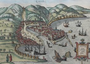
Crete – Heraklion (Irákleio) commented by Braun
“Candia is the name of the capital after which the island is also named. Acting like a wall the surrounding mountains fortify the town, it has a harbour, protected naturally and by human hands so that ships can dock safe from the ravages of the sea, with a strong and sturdy tower, from which the harbour, with all its commodities, can be protected from enemy attack.”
Taschen on Crete – Heraklion (Irákleio)
The plate depicts the town of Heraklion, on the north coast of Crete, from the sea. The town was settled as early as the Bronze Age by the Minoans, one of the earliest advanced civilizations in Europe. From c. 1100 BC the Dorians lived here; they named their settlement Herakleia, because, according to mythology, Heracles captured the Cretan Bull here. Following Byzantine rule (395-1204) Crete became, in the 13th century, part of the Republic of Venice, when the name was Italianized to “Candia”, which was used to designate the entire island. In 1239 the Venetians erected St Mark’s basilica, the Agios Markos (centre), and the archdiocese. Ottoman attacks in the 15th and 16th centuries led to the construction of the formidable 5.5-km-long city wall and to a fortress in the harbour.
Corfu (Kérkyra) commented by Braun
“This town lies on the island of Corfu, in a range of mountains that juts into the Ionian Sea. At the highest point of these mountains lies a castle, called the New Castle, and on a lower point, one that is called the Old Castle. Both have well-fortified walls and are covered with mighty battlements and bastions.”
Taschen on Corfu
The bird’s-eye view from the east depicts the town of Corfu with the island, seen in the foreground, where both the New and Old Castle are located. The town of Corfu was founded around 590 BC with the erection of the Artemis Temple. According to Homer, Odysseus was stranded here and taken in by the emperor’s daughter Nausikaa. From 229 BC Corfu belonged to the Roman Empire, and from AD 395 to the Byzantine Empire. The Old Castle was built in the 6th century; in the 16th century it was extended with the structure titled here Castell Novo.
Related items
You may also be interested in:

Lucca

Portrait Abraham Ortelius, by Galle

China, Tartary and Japan
The first modern map of China printed in Europe

Avignon
Papal city²