


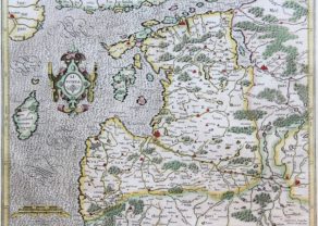
Chart of the Gulf of Finland
by
Lucas Janszoon Waghenaer
Detail
Date of first edition: 1584
Date of this edition: 1600
Dimensions (not including margins and text at top): 32,5 x 51 cm
Dimensions (including margins): 39,4 x 54 cm
Condition: Excellent. Old coloring. Centre fold as published. Some minor age toning in margins.
Condition rating: A+
Verso: text in French
Map reference: Koeman IV, Wag 35b
From: Le nouveau mirroir des voyages et navigations. Jean Bellère, Antwerpen, 1600. Koeman Wag 11A
Unless otherwise specifically stated on this map page, we charge the following expedition costs in euro (unfortunatelly, gone up with Covid, but still too low in reality!):
– Benelux: 40 euro
– Rest of Europe: 60 euro
– Rest of the World: 100 euro
This item is sold
Original title: Het Wterste ofte oosterste Deel van de Oster Zee, Beslooten tegens Russlandt Lijflandt, Oost Finlandt
Related items
You may also be interested in:

Achaia, Attica and Gulf of Corinth
by
Johannes Janssonius
Price (without VAT, possibly to be added): €450,00 / $499,50 / £400,50

Edinburgh
by
Georg Braun and Frans Hogenberg
Price (without VAT, possibly to be added): €1 700,00 / $1 887,00 / £1 513,00

Algiers – Algerii Saracenaorum Urbis Fortissimae…
by
Georg Braun and Frans Hogenberg
Price (without VAT, possibly to be added): €800,00 / $888,00 / £712,00

San Adrian (Navarre) – La Sierra de Sant Adrian en Biscaia
by
Georg Braun and Frans Hogenberg
Price (without VAT, possibly to be added): €700,00 / $777,00 / £623,00
A surprising map
This chart ( = a sea map ) shows the extreme east of the Gulf of Finland, showing “Ost Finlandt, “Ruslandt” and “Lyflandt”. Top left (northeast) is controversial Wijburgh (Vyborg), which became Russian since 1944 (after Soviet invasion), together with the entire Karelian Isthmus between the Gulf of Finland and Lake Ladoga, Russian. The top right is located Duitzsche Narwa. In 1346 the Danish rulers sold the city to the Teutonic Knights, hence the name. In 1492 Ivan III (“the Great”) built across the River Narva the town “Iwangorod” (on the map marked with the name Iwangrot.
More or less lands in the middle of the map lies Hooge island is (Hogland), the largest island in the Finnish Golf and now an advanced Russian naval base. Other toponyms are much harder recognizable Kiuaneb was Finnish Kivineppa located on the Karelian isthmus, and is currently called Pervomayskoye. Further: Telsborchis possibly Kunda in Estonia; and in Finland Reisanburg and Vekelax maybe are respectively Hamina and Valkeala.