Iucatana regio et fondura
Full of history
Detail
Date of first edition: 1597
Date of this map: 1597
Dimensions of the map (not including margins): 23,3 x 28,5 cm
Dimensions (including margins): 27 x 34,8 cm
Condition: Very good. Sharp print. Centre fold as published. Wide margins.
Condition rating: A+
Verso: blank
Map reference: Van der Krogt III,B 9550:371, page 11 (top right); Mickwitz & Miekkavaara #307-11.
From: Descriptionis Ptolemaicae Augmentum; Van der Krogt, IIIB, 371:01-13
This item is sold
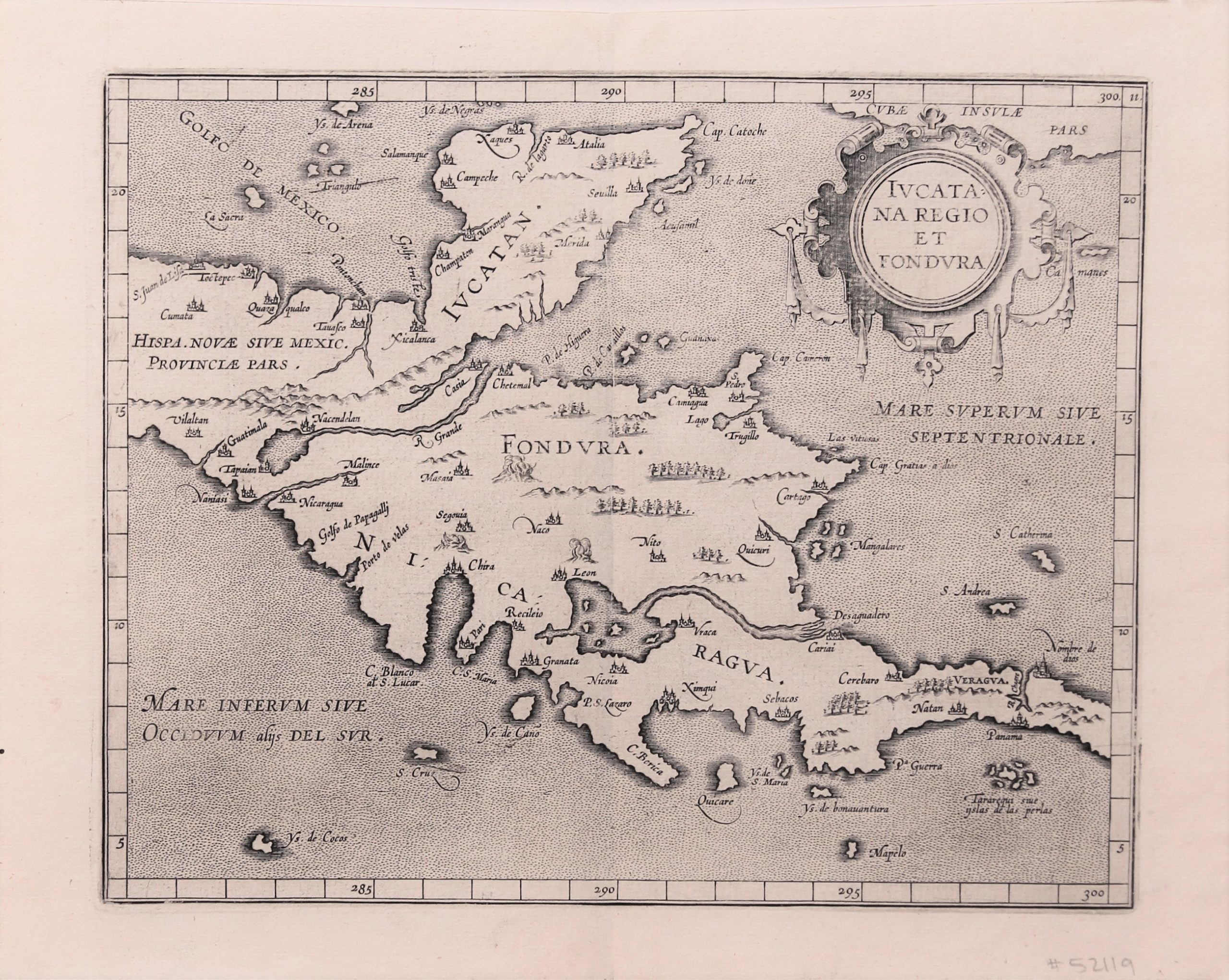
Iucatana Regio et Fondura
On his fourth and final voyage from 1502, Columbus explored the coasts of Honduras, Nicaragua, Costa Rica and Panama for months (landing in Almirante Bay). In 1517 Francisco Hernández de Córdoba led the Spanish Yucatan expedition. Unfortunately, this map does not provide clear information about the major Mayan sites in Yucatan. At first glance, the two enormous (but nameless) lakes are striking. They are probably the Lago de Izabel in Guatemala (north) and the even larger Lago Nicaragua in Nicaragua (the south). However, the river that runs from the latter lake to the Caribbean Sea does not exist because a long mountain range cuts off its way out to this sea. Nicaragua and Honduras are fertile volcanic countries.
The center of the map shows three volcanoes in full eruption. A number of cities are clearly depicted: Nicaragua (is this Managua?), Léon and Granata (in Nicaragua) and also Guatemala and Panama. Similarly Cap. Gracias a Dios, the majestic promontory that forms the international border between Honduras and Nicaragua, as defined by King Alfonso XIII of Spain in 1906. The name comes from Columbus. When arrived in a quiet are after a violent storm coming from northern Honduras on his last voyage in 1502, he finds himself in a quiet area (now Nicaragua), “he thanked God.” Hence “Cap. Gratias a dios”.
Magini republished the atlas in 1605, but he replaced this map with four smaller views of Southeast Asia, China, Japan and the Philippines for his atlas.

Cornelius Wytfliet (? – 1597)
Cornelius Wytfliet was a geographer from Leuven. After graduating Licentiate in Laws from the University of Leuven, Wytfliet moved to Brussels and became secretary to the Council of Brabant.
In 1597 he published the first atlas of America: the Descriptionis Ptolemaicae Augmentum (Augmentation to Ptolemy’s description). He named his work an augmentation to Ptolemy’s Geography because it covers the Americas, a part of the world unknown to Ptolemy. However, there is no other connection between the works of Ptolemy and Van Wytfliet. Dedicated to Philip III of Spain it is a history of the New World to date, recording its discovery, natural history, etc. It provides a history of exploration and the voyages of Christopher Columbus (1492-1502), John Cabot (1497-98), Sebastian Cabot (1526-28), Francisco Pizarro (1527-35), Giovanni de Verazzano (1524), Jacques Cartier (1540-42), and Martin Frobisher (1576-78). Most of Van Wytfliet’s maps are the first or among the earliest of specific regions of North and South America.
For the book, Wytfliet had engraved nineteen maps, one of the world and eighteen regional maps of the Americas. The book was an immediate success and ran to several editions.
Two editions of the Descriptionis Ptolemaicae were published et Leuven in 1597 and 1598. In 1603 appeared the first Douai edition with later editions with French text. The last edition was published in Arnhem in 1615.