


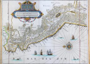
Peru – Peruani Regni descriptio
Detail
Date of first edition: 1597
Date of this map: ca. 1597
Dimensions of the map (not including margins): 23 x 29 cm
Dimensions (including margins): 29 x 36,8 cm
Condition: Excellent. Centre fold as published. Wide margins.
Condition rating: A+
Verso: blank
Map reference: Van der Krogt 2, 9820:371:1, page 5 (top right)
From: Descriptionis Ptolemaicae Augmentum; Van der Krogt 371:01-13
In stock
Peru by Wytfliet
Peruani regni descriptio also includes parts of Bolivia, Ecuador and western Brazil outside of Peru. The region was of particular importance to the Spanish government because of its gold and silver veins. Both the Maragnon (Maranon) and the Paucarmayo (Ucayali), both of which originate in Peru, dominate the Peruvian Amazon water system. It is only from their confluence that the stream is called Amazon. The map shows the Inca land as it was conquered by Pizarro (together with de Soto) after the decisive battle of Chamarra in 1532.
The following pre-Inca sites are listed:
• Pachama (temple): Pacha Kamaq or “creator of the earth” was worshiped by the population living in these areas before the arrival of the Incas;
• Nasca: southern coastal city, with a name that refers to the Nazca culture that existed between 100 BC. and 800 flourished. The so-called Nazca lines in the landscape are known.
In addition, some important Inca settlements are noted:
• Cuzco: capital of the Inca Empire until 1533;
• Quito: its origins date back to the first millennium, when the Suitus tribe populated this region. The Incas conquered this area in 1462.
Machu Picchu is invisible. This site was abandoned by the Incas around 1572 and there would be no evidence of any Spanish presence there. Machu Picchu did not receive international attention until the American archaeologist Hiram Bingham rediscovered it in 1911.
In addition, the map shows a number of Spanish settlements:
- Guaiaquil: Ecuadorian coastal city and port, founded by the Spaniards who did not consider inland Quito suitable. Incidentally, also the largest city in the country;
- Trujiilo: founded by Diego de Almagro on December 6, 1534, now the third city of Peru;
- Lima as sheet Reg. civitatis: Pizarro already founded this in 1533. In 1541 he was murdered in his palace in Lima in a failed coup d’état by Diego de Almagro II, son of Diego de Almagro. He is buried in the cathedral of Lima. Lima was already elevated to a Spanish colonial capital in 1535;
- Callao: misleadingly placed next to the island outside Lima that is actually called Isla San Lorenzo. Callao is Lima’s outer port on the mainland;
- Potosí: on the south side of the Titicaca lacus, founded in 1546 as a silver mining community; now located in Bolivia;
- Arequipa: all the way on the coast in the south. This city was founded in 1540 by Garcí Manuel de Carbajal as Villa Hermosa de Nuestra Señora de la Asunción. Between 1835 and 1883 it was even the capital of independent Peru. Now the second city in the country.
Picora Provincia is now called Picota. Arequipa’s placement shows the massive distortion of the map. Wytfliet places the city far south of Lake Titicaca, when in reality it is roughly level with the center of the lake’s north-south axis. Maps of Peru were certainly not an oddity. Wytfliet probably knew the map of Ortelius.
Related items
You may also be interested in:

Luxembourg, Duchy

Toledo (Castile) – Toletum

Cuzco (Inca capital)
Rare first edition (block destroyed by fire)

Cornelius Wytfliet (? – 1597)
Cornelius Wytfliet was a geographer from Leuven. After graduating Licentiate in Laws from the University of Leuven, Wytfliet moved to Brussels and became secretary to the Council of Brabant.
In 1597 he published the first atlas of America: the Descriptionis Ptolemaicae Augmentum (Augmentation to Ptolemy’s description). He named his work an augmentation to Ptolemy’s Geography because it covers the Americas, a part of the world unknown to Ptolemy. However, there is no other connection between the works of Ptolemy and Van Wytfliet. Dedicated to Philip III of Spain it is a history of the New World to date, recording its discovery, natural history, etc. It provides a history of exploration and the voyages of Christopher Columbus (1492-1502), John Cabot (1497-98), Sebastian Cabot (1526-28), Francisco Pizarro (1527-35), Giovanni de Verazzano (1524), Jacques Cartier (1540-42), and Martin Frobisher (1576-78). Most of Van Wytfliet’s maps are the first or among the earliest of specific regions of North and South America.
For the book, Wytfliet had engraved nineteen maps, one of the world and eighteen regional maps of the Americas. The book was an immediate success and ran to several editions.
Two editions of the Descriptionis Ptolemaicae were published et Leuven in 1597 and 1598. In 1603 appeared the first Douai edition with later editions with French text. The last edition was published in Arnhem in 1615.