


New York (Manhattan – Brooklyn – Williamsburg – Jersey)
Detail
Date of first edition: 1840
Date of this map: 1852
Dimensions (without margins): 30,2 x 37 cm
Dimensions (including margins): 34,3 x 41 cm
Condition: Very good. Sharp steel engraving. Wide margins, with small tear in top margin (not affecting map). Old coloured.
Condition rating: A
Verso: blank
In stock
SDUK and New York
This map focuses on the 19th century development of New York.
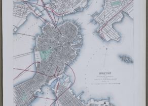
This is an 1840 Society for the Diffusion of Useful Knowledge (S.D.U.K.) city map or plan of New York City. The map depicts southern Manhattan from the Battery northwards to 42nd Street as well as portions of adjacent Jersey City, Brooklyn, and Williamsburg. Governors Island and Ellis Island appear in the harbor. Massive proposed docks on the Hudson River, none of which actually materialized, as well as tentative landfills on the East Side and in Williamsburg are ghosted in. Shading illustrates the areas of heaviest development in each of the three cities. In Manhattan, specifically, no less than 40 important buildings are identified numerically and by a key in the upper right quadrant. Several ferry lines are illustrated crossing both the Hudson and East Rivers. Red highlighting indicates railroad lines and tramways.
Engraved views illustrating ‘Broadway from the Park’, that being City Hall Park with Trinity Church clearly visible in the background, and City Hall itself, are situated in the lower left and lower right corners, respectively.
It mentions Charles Knight as the map maker and mentions January 1, 1852.
Related items
You may also be interested in:

Edinburgh

The Eastern Hemisphere – Hemisphaerium Orbis Antiqui

Cuzco (Inca capital)
Rare first edition (block destroyed by fire)

[Untitled] Japan
Very rare: oldest map of Japan, and … based on Polo’s description
SDUK
SDUK is short for Society for the Diffusion of Useful Knowledge. The idea for the Society was conceived by Henry Brougham, born in Edinburgh in 1778. In the 1820’s he was actively involved in educational reform and hence the SDUK with the object of publishing information for people belonging to the working class and middle classes who were unable to get formal education or preferred the idea of self education. A map committee was established in 1828. The cheap maps were, however, very accurate in detail. Over a period of 14 years the series expanded to 209 plates with over 3 millions maps being sold; first as part works on subscription and from 1844 in a variety of bound atlases. Up until 1842 the design and engraving was under the direct control of the SDUK using the publishers Balwin and Craddock until their insolvency. From 1842 to 1844 the maps were published by Chapman and Hall, Charles Knight from 1844 to the completion of the series in 1846. Knight continued the publishing until 1852 when the plates were sold to George Cox and then Edward Stanford in 1856. The plates were later acquired by Thomas Letts in 1877 and then finally by Mason & Payne in 1885.