

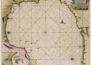
Chart of New England – Pas-kaart vande Zee Kusten inde Boght van Niew Engelnd tusschen de Staaten Hoek en C. de Sable
by
Johannes van Keulen
Cartographer was C.J. Vooght
Detail
Date of first edition: 1684
Date of this edition: 1697-1709
Dimensions (not including margins): 50,31,2 x 58 cm
Dimensions (including margins): 53,5 x 62,5
Condition: Excellent. Nice outline colouring. Wide margins, except top limited to 0.5 cm
Condition rating: A
Verso: blank
Map reference: Koeman, Keu (136); Burden state 3 of 4
From: De nieuwe Groote Lichtende Zee-Fakker, Amsterdam
Unless otherwise specifically stated on this map page, we charge the following expedition costs in euro (unfortunatelly, gone up with Covid, but still too low in reality!):
– Benelux: 40 euro
– Rest of Europe: 60 euro
– Rest of the World: 100 euro
This item is sold
T
Related items
You may also be interested in:

China, Tartary and Japan
by
Lorenz Fries (after Martin Waldseemüller)
Price (without VAT, possibly to be added): €4 000,00 / $4 440,00 / £3 560,00
The first modern map of China printed in Europe

Algiers – Algerii Saracenaorum Urbis Fortissimae…
by
Georg Braun and Frans Hogenberg
Price (without VAT, possibly to be added): €800,00 / $888,00 / £712,00

Michiel de Ruyter, a super collection by Stoopendaal
by
Daniël Stoopendaal
Maybe the greatest admiral of all times

Map of the Moon – Tabula Selenographica in qua Lunarium
by
Johann Gabriel Doppelmayr
Price (without VAT, possibly to be added): €3 500,00 / $3 885,00 / £3 115,00
The unique and famous first comparative chart of the Moon (with double competing nomenclature) from which the names of many lunar features have been derived.