


Mauritius and Banda islands
by
Jan Janszoon Orlers
Interesting picture of history
Detail
Date of first view: 1610
Date of this view: 1610
Dimensions (not including margins; the view only): 23 x 33 cm
Dimensions (including margins): 30,6 x 41,3 cm
Condition: mint. Sharp copper engraving. Nice colouring. Wide margins.
Condition rating: A+
Verso: blank
From: Den Nassauschen Lauren-Crans: Beschrijvinghe ende af-beeldinge van alle de victorien … die Godt Almachtich de … Staten der Vereenichde Nederlanden verleent heeft, deur het wijs ende clouck beleyt des Hooch-ghebooren Fursts Maurits van Nassau, J.J. Orlers en H. van Haestens, Leiden, 1610
Price (without VAT, possibly to be added): €400,00 (FYI +/- $444,00 / £356,00)
Unless otherwise specifically stated on this map page, we charge the following expedition costs in euro (unfortunatelly, gone up with Covid, but still too low in reality!):
– Benelux: 40 euro
– Rest of Europe: 60 euro
– Rest of the World: 100 euro
In stock
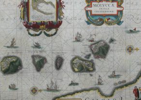
Mauritius and Banda islands
The views are:
- top left: the island of Mauritius. Remark the dodo!
- top right: Banda islands of Gunnanappi, Labetacq and Ortatan
- bottom left: the town of Gamme Lamme with a procession for the king of Ternate. Also a palace (palatio) and mosque (mesquito)
- bottom right: the town of Tubate (Tuban) with the king on an elephant
Related items
-
Moluccas
by Willem and Joan BlaeuPrice (without VAT, possibly to be added): €1 000,00 / $1 110,00 / £890,00Going for spices
-
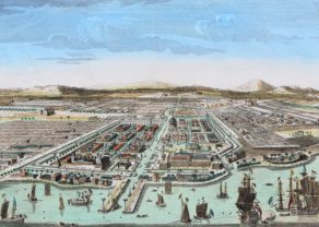
Batavia
by Gabriel HuquierPrice (without VAT, possibly to be added): €450,00 / $499,50 / £400,50Interesting picture in history
-
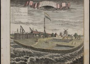
Onrust – Ein Prospect der Insul Onrust oder Unruhe 2. Meilen von Batavia gelegen
by W.J. HeydtPrice (without VAT, possibly to be added): €600,00 / $666,00 / £534,00The VOC workshop in Batavia
You may also be interested in:

Lucca
by
Georg Braun and Frans Hogenberg
Price (without VAT, possibly to be added): €700,00 / $777,00 / £623,00

Lisbon
by
Georg Braun and Frans Hogenberg
Price (without VAT, possibly to be added): €1 300,00 / $1 443,00 / £1 157,00

Luxembourg, Duchy
by
Abraham Ortelius
Price (without VAT, possibly to be added): €750,00 / $832,50 / £667,50

Chester – Cestria vulgo Chester, Angliae Civitas
by
Georg Braun and Frans Hogenberg
Price (without VAT, possibly to be added): €900,00 / $999,00 / £801,00