


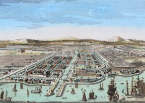
Onrust – Ein Prospect der Insul Onrust oder Unruhe 2. Meilen von Batavia gelegen
Rare 1st edition
Detail
Date of first edition: 1739
Date of this map: 1744
Dimensions (not including margins): 22,5 x 27 cm
Condition: very good, strong paper and wide margins. Still framed.
Condition rating: A+
Verso: blank
From: Allerneuester geographisch- und topographischer Schauplatz von Africa und Ost-Indien… Landwehr, VOC 469, NHSM 241, Mendelssohn I, 709, Kainbacher 174, Rajpal Kubar de Silva, Willemina G.M. Beumer: Illustrations and views of Dutch Ceylon, 1602-1796. A comprehensive work of pictorial reference with selected eye-witness accounts. London 1988. Gita Dharampal-Frick: Indien im Spiegel deutscher Quellen der Frühen Neuzeit (1500-1750). Studien zu einer interkulturellen Konstellation. Tübingen 1994. Christian Sandler: Die Homannschen Erben (1724-1852) und ihre Landkarten. Das Leben und Wirken von Johann Georg Ebersperger (1695-1760) und Johann Michael Franz (1700-1761).
In stock
Related items
You may also be interested in:

Jan Mayen – Insulae Johannis Mayen Cum universe situ Sinuum et Promontariorum
Rare Spanish edition

Bristol – Brightstowe, Vulgo; Quondam Venta, Florentissimum

Toledo (Castile) – Toletum

[Untitled] Japan
Very rare: oldest map of Japan, and … based on Polo’s description
Onrust, Batavia’s key island
W. Heydt was a German engraver serving the VOC. In 1744 he published “Allerneuester geographisch- und topographischer Schauplatz von Africa und Ost-Indien….” in Nürenberg. This book contains many drawings pf Batavia, where Heydt lived between 1737 and 1740 as well as 41 engravings which he made for the Governor-General Valckenier.
VOC ships could not harbor at Batavia port. Hence the Dutch located all maritime activities on this tiny island just of the coast of Batavia.