


Ancient France or Gaul – Galliae Veteris
Detail
Date of first edition: 1595
Date of this map: 1601
Dimensions (not including margins): 39,5 x 49,5 cm
Dimensions (including margins): 43,5 x 56,7 cm
Condition: excellent. Sharp copper engraving printed on strong paper. Centre fold is as published (with small professional repair at top). Old coloured. Wide margins.
Condition rating: A+
Language: Latin text
Map reference: Van den Broecke 196; Van der Krogt 31:052, page xj (back)
From: Theatrum Orbis; van der Krogt 4000:H:31B
In stock
Ortelius’ Gaul or back to Julius Caesar
Vivid map of Ancient France from Ortelius’ Parergon, the first historical atlas. The map is based upon information from classical sources such as Strabo, Virgil, Ovid and Caesar.
It differs from Ortelius’ similar Galliae Vetus map in that it is based upon ancient geographical sources, rather than ancient military sources, making it substantially more detailed.
Oriented northward, this map displays Ancient France, from its border with Spain (Hispaniae pars) in the southwest to Great Britain (Britanniae pars) in the northwest. The map also stretches east to Germany (Germaniae Magnae pars) and Italy (Italiae Gallicae pars). The country is divided into four main provinces, which make up this area of the Roman Empire: Belgica, Celtica Lugdunensis, Narbonensis, and Aquitanica.
This map is characterized by excellent attention to detail. The shape of the coastline is fairly accurate, which is unsurprising given that Europe was well mapped by Ortelius’ time. Rivers are carefully rendered, and throughout the map mountain ranges and forests give the land texture. In particular, the Pyrenees Mountains (Pyrenaei montes) dividing Spain and France and the Alps (Alpes) near Italy are notable. These details help to orient the viewer and give a sense of the physical geography of the land.
Cities are represented with miniature views, which is typical of Ortelius maps. Some may be recognizable to the casual viewer as well-known cities today, such as London (Londinum) in Great Britain, Geneva on Lake Geneva (Lemanus lacus), and Paris (Parisii) in north-central France.
Some water bodies such as the Mediterranean Sea (Mediterranei Maris pars) and the English Channel (Oceanus Britannicus) can be seen around the edges of the map. Filling them in with stippling gives the water a bit of texture without distracting from the many labels and locations on the map. A pair of decorative ships also sail the more northern waters.
Two beautiful cartouches adorn the map. In the southwest corner, the title cartouche is particularly ornate. It indicates the subject of the map, Ancient France (Galliae Veteris). A simpler cartouche in the northeast corner dedicates the map to two renowned noblemen, Lord Edward van der Delft and Carolus from Mechelen. These strapwork cartouches employ texture and shading which give them a vivid appearance. The title cartouche also includes figural elements, flora, and fauna.
Related items
-
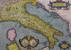
Ancient Italy – Italiae Veteris Specimen
by Abraham OrteliusPrice (without VAT, possibly to be added): €1 000,00 / $1 110,00 / £890,00 -
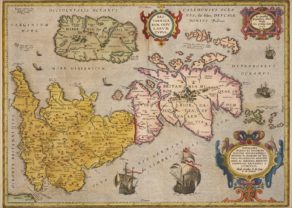
Ancient British Isles – Britannicarum Insularum Typus
by Abraham OrteliusPrice (without VAT, possibly to be added): €900,00 / $999,00 / £801,00 -
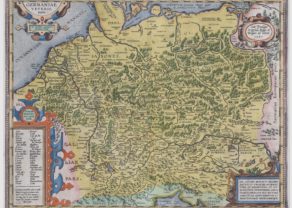
Ancient Germany – Germaniae Veteris Typus
by Abraham Ortelius
You may also be interested in:

Avignon
Papal city²

Algiers – Algerii Saracenaorum Urbis Fortissimae…

Jan Mayen – Insulae Johannis Mayen Cum universe situ Sinuum et Promontariorum
Rare Spanish edition
