A plan of the city and harbour of Macao
by
George Nicol
Superb piece of history
Detail
Date of first edition: 1796
Date of this map: April 12, 1796
Dimensions (not including margins): 68,7 x 52,4 cm
Condition: Excellent. Centre fold as published.
Condition rating: A+
From: Atlas of Maps, Charts, Sections, Picturesque Views, etc. to illustrate the “Voyave of Lord Macartney, on his Embassy to China, 1796.
Price (without VAT, possibly to be added): €2 000,00 (FYI +/- $2 220,00 / £1 780,00)
Unless otherwise specifically stated on this map page, we charge the following expedition costs in euro (unfortunatelly, gone up with Covid, but still too low in reality!):
– Benelux: 40 euro
– Rest of Europe: 60 euro
– Rest of the World: 100 euro
In stock


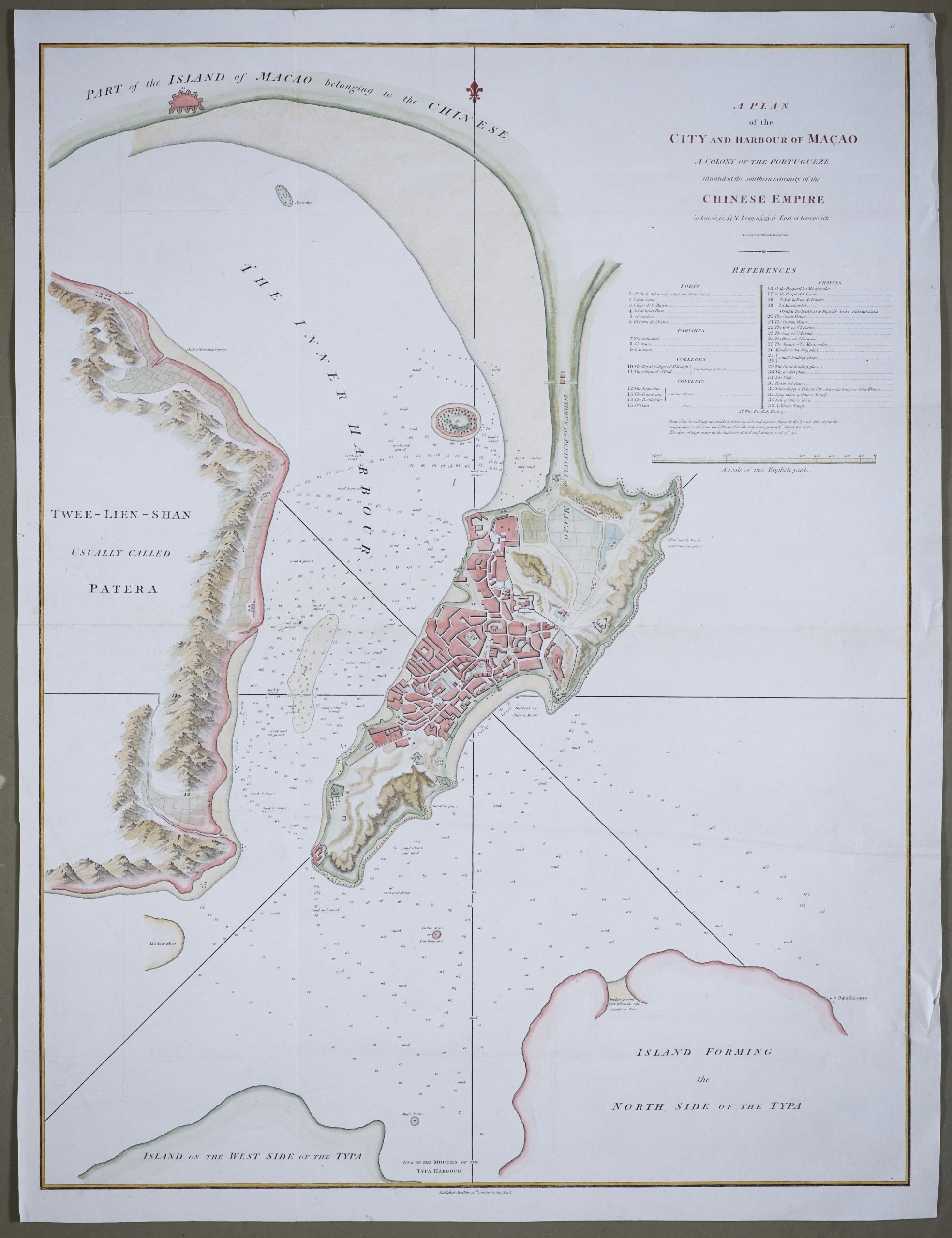
Large chart of Macao: a colony of the Portuguese, situated at the southern extremity of the Chinese Empire
This map was engraved by Benjamin Baker (fl. 1766-1824) and published by George Nicol. The town is shown in detail, with a 37-point key in English listing Forts, Parishes, Colleges, Convents, Chapels and other buildings of interest including the Customs House and the English Factory and extensive sounding depths. Terrain is shown as engraved hills and the waters are filled with soundings and notations on type of bottom. The fortified city of Tchinshang is shown well north of Macao. This uncommon map was engraved by B. Braker & Islington and published in George Staunton’s ‘An Authentic Account of an Embassy from the King of Great Britain to the Emperor of China’, Britain’s first official embassy to China.
Lord Macartney was the first British ambassador to China, arriving in 1793 and ordered to leave the same year. However in the short time the embassy was in the country much was learned about China, and the groundwork was laid for the founding of Hong Kong less than fifty years later. Macartney was dispatched to Beijing in 1792, traveling via Madeira, Tenerife, Rio de Janeiro, the Cape of Good Hope and Indonesia. He was accompanied by Staunton, and a retinue of suitably impressive size, including Staunton’s 11-year-old son who was nominally the ambassador’s page. On the embassy’s arrival in China it emerged that the 11-year-old was the only European member of the embassy able to speak Mandarin, and thus the only one able to converse with the Emperor. The embassy, the first such to China, had two objectives: the first to register with the Emperor, British displeasure at the treatment that the British merchants were receiving from the Chinese, the second to gain permission for a British minister to be resident in China.
The first objective was achieved, the second was not. Macartney was twice granted an audience with the Emperor and in December 1793 he was sumptuously entertained by the Chinese viceroy in Canton, and returned to England via Macao and St. Helena, arriving in September 1794.
This important text produced some of the earliest accurate maps of the interior of China and provided many invaluable geographical and cultural observations.
The map specifies the location of the city: “in lat. 22 °12ʹ44ʺ N., long. 113°35ʹ0ʺ east of Greenwich”