
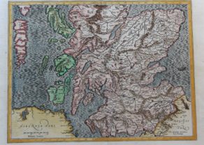
Scotland – Nova Scotia
by
Willem and Joan Blaeu
With inset: Orcades Insulae
Detail
Date of first edition: 1634 in Theatrum Orbis Terrarum, sive, Atlas novus (Willem Blaeu), 1635
Date of this edition: ca. 1647 (Joan Blaeu)
Dimensions (not including margins): 38 x 49,5 cm
Condition: excellent. Sharp copper engraving printed on hard paper. Centre fold is as published. Superb old hand coloured. Wide margins.
Condition rating: A+
Verso: blank
Reference: Koeman/van der Krogt, Atalantes Neerlandici 5800: 2A
From: Theatrum Orbis Terrarum, sive, Atlas novus
Price (without VAT, possibly to be added): €1 000,00 (FYI +/- $1 110,00 / £890,00)
Unless otherwise specifically stated on this map page, we charge the following expedition costs in euro (unfortunatelly, gone up with Covid, but still too low in reality!):
– Benelux: 40 euro
– Rest of Europe: 60 euro
– Rest of the World: 100 euro
In stock
Related items
-

Edinburgh
by Georg Braun and Frans HogenbergPrice (without VAT, possibly to be added): €1 700,00 / $1 887,00 / £1 513,00 -
South Scotland – Scotiae parts septentrionalis
by Gerard Mercator, Jodocus Hondius Jr.Price (without VAT, possibly to be added): €500,00 / $555,00 / £445,00Per Gerardum Mercatorem
Cum privilegio
-
Ancient British Isles – Britannicarum Insularum Typus
by Abraham OrteliusPrice (without VAT, possibly to be added): €900,00 / $999,00 / £801,00 -
Chart of the British Isles
by Johannes van LoonRare and exceptional map
You may also be interested in:

Avignon
by
Georg Braun and Frans Hogenberg
Papal city²

Toledo (Castile) – Toletum
by
Georg Braun and Frans Hogenberg
Price (without VAT, possibly to be added): €1 500,00 / $1 665,00 / £1 335,00

Antequera (Andalusia)
by
Georg Braun and Frans Hogenberg
Price (without VAT, possibly to be added): €475,00 / $527,25 / £422,75

Map of the Moon – Tabula Selenographica in qua Lunarium
by
Johann Gabriel Doppelmayr
Price (without VAT, possibly to be added): €3 500,00 / $3 885,00 / £3 115,00
The unique and famous first comparative chart of the Moon (with double competing nomenclature) from which the names of many lunar features have been derived.
Visit Blaeu’s Scotland!
Scotia Regnum: The Kingdom of Scotland emerged as an independent sovereign state in the Early Middle Ages and continued to exist for several centuries until 1707. By inheritance in 1603, James VI, King of Scots, became King of England and King of Ireland, thus forming a personal union of the three kingdoms. On 1 May 1707 Scotland entered into a political union with the Kingdom of England to create the new Kingdom of Great Britain.
This is a very attractive copy of Blaeu’s first map of the Kingdom, based on Mercator’s of 1595. Although first published in 1634, this example, lacking text on the reverse was probably issued around 1660. FYI: The Antonine Wall (constructed 142 AD) runs more or less from Glasgow to Edinburgh. Hadrian’s Wall (constructed 122 AD) runs from famous Scottish Gretna Green (in the West; and still border town; this town became famous from 1754 since the English Marriage’s Act prohibited under the age of 21 marrying in England or Wales without their parent’s consent; see picture) straight east; so this Wall is not coinciding with current borders.
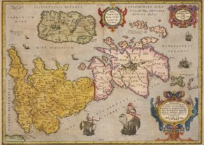
The northeastern border town is Berwick (clearly visible on the map).In terms of size, it covers one third of the island of Great Britain. It is home to almost 800 small stunning islands, including the northern isles of Shetland (not on the map) and Orkney (see inset), the Hebrides, Arran (yellow below) and the long and superb Skye (green; see second picture). In green (left bottom) one recognizes the northern coastline of Ireland. Loch Ness prominently features as the long (somewhat too broad lake in the top middle of the map.
On 18 September 2014 a referendum on Scottish Independence from the United Kingdom took place in which 55.3% voted in favor of the union. Then, only Greater Glasgow and Dundee voted in majority for independence. In the 2016 EU referendum all of the 32 constituencies of Scotland voted Remain, with an overall favorable vote of 68%.
So Scotland, quo vadis?