

Beijing
Detail
Date of this map: 1760
Dimensions (not including margins): 10 x 14 cm
Dimensions (including margins): 13,5 x 21 cm
Condition: Very good. Sharp print. Nice colouring.
Condition rating: A
Verso: text in French
In stock
Alain Manesson Mallet
Alain Manesson Mallet (1630–1706) was a French cartographer and engineer. He started his career as a soldier in the army of Louis XIV, became a Sergeant-Major in the artillery and an Inspector of Fortifications. He also served under the King of Portugal, before returning to France, and his appointment to the court of Louis XIV. His military engineering and mathematical background led to his position teaching mathematics at court. His major publications were Description de L’Univers (1683) in 5 volumes, and Les Travaux de Mars ou l’Art de la Guerre (1684) in 3 volumes.
His Description de L’Universe contains a wide variety of information, including star maps, maps of the ancient and modern world, and a synopsis of the customs, religion and government of the many nations included in his text. It has been suggested that his background as a teacher led to his being concerned with entertaining his readers. This concern manifested itself in the charming harbour scenes and rural landscapes that he included beneath his description of astronomical concepts and diagrams. Mallet himself drew most of the figures that were engraved for this boo
Related items
-
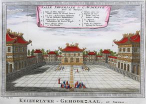
Beijing Imperial court – Salle Impériale des audiences
by Antoine-François PrévostPrice (without VAT, possibly to be added): €250,00 / $277,50 / £222,50 -
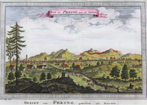
Vue de Peking
by Jacques Nicolas Bellin, Antoine-François PrévostPrice (without VAT, possibly to be added): €175,00 / $194,25 / £155,75Geographically very well detailed at every point
You may also be interested in:

Asia Secunda pars Terrae in Forma Pegasi

[Untitled] Japan
Very rare: oldest map of Japan, and … based on Polo’s description

The Eastern Hemisphere – Hemisphaerium Orbis Antiqui

Avignon
Papal city²