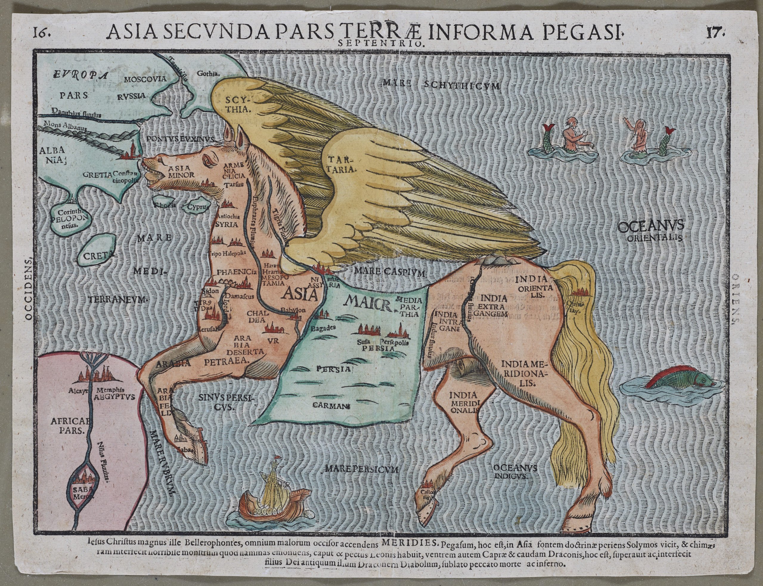
Asia Secunda pars Terrae in Forma Pegasi
Detail
Date of first edition: 1581
Date of this edition: 1581
Dimensions (not including margins): 24 x 35 cm
Condition: excellent. Sharp wood engraving printed on paper. Centre fold is as published. Old colouring. Wide margins.
Condition rating: A+
Verso: text in German
Reference:
From: Itinerarium Sacrae Scriptura, 1981, Magdeburg; Hill p.39; Suarez Fig. 54; Tooley, MCC-1 # 3; Yeo #8.
This item is sold
Pegasus Asia by Bünting, a dissection
Bünting’s work Itinerarium Sacrae Scriptura was essentially a theological commentary with other maps of great curiosity, an unusual travel book based on the Bible. It contains among the earliest cartographic oddities. The title of this map is Asia Secunda Pars Terrae in Forma Pegasi (’Asia, the Second Part of the Earth, in the Form of Pegasus‘). Pegasus, the winged horse of Greek mythology, is the son of Poseidon and Medusa, was tamed by Athena and became the horse of the Muses. On this map, Pegasus is drawn realistically – i.e. Asia is adjusted to horse-shape.
– Asia’s front legs constitute Arabia, touching Africa with the Nile delta and Memphis.
– Its head, Asia Minor (present-day Turkey); with the mouth open at Constantinople (Istanbul).
– The proud breast shows Antiochia, Syria, Sidon, Damascus and Jerusalem and a wide Jordan River.
– The Tigris and Euphrates rivers run down its neck, on which is marked the area of Mesopotamia.
– Persia is delineated on the horse blanket with Persepolis.
– Another river indicated, at the horse’s thigh, is the Ganges, with India Infra Gangem (‘India before the Ganges’) to the west and India Extra Gangem (‘India across the Ganges’).
– The horse’s behind is India Orientalis (’East India‘, which could be used for parts east of present-day India, e.g. Indonesia, formerly the Dutch East Indies).
– Both hind legs are inscribed with India Meridionalis (’South India’), which doesn’t at all reflect the single-peninsular nature of the Indian subcontinent.
– The wings are labeled Scythia and Tartaria, names often used to describe the vast unknown areas of Siberia.
– The body of water in between the wings and the horse’s body is the Caspian Sea.
– The seas are adorned with sea monsters and many major cities are indicated and named.
This obviously pagan origin of the image makes its appearance in a Holy Land travel book a bit of a mystery.
Related items
-
China, Tartary and Japan
by Lorenz Fries (after Martin Waldseemüller)Price (without VAT, possibly to be added): €4 000,00 / $4 440,00 / £3 560,00The first modern map of China printed in Europe
-
Tartary – A Newe Mape of Tartary
by John SpeedPrice (without VAT, possibly to be added): €2 000,00 / $2 220,00 / £1 780,00Rare Tartary
