


Southeast Asia (Bay of Bengal) – Tabula Asiae XI
by
Sebastian Münster
Detail
Date of first edition: 1540
Date of this map: 1542
Dimensions (not including margins): 26 x 34 cm
Dimensions (including margins): 32 x 43 cm
Condition: Very good. Sharp woodcut engraving on strong paper and wide margins. Centre fold as published. Original colouring.
Condition rating: A+
Verso: text in Latin (nicely colored)
From: Geographia Universalis vetus et nova, Petri, Basel.
Price (without VAT, possibly to be added): €900,00 (FYI +/- $999,00 / £801,00)
Unless otherwise specifically stated on this map page, we charge the following expedition costs in euro (unfortunatelly, gone up with Covid, but still too low in reality!):
– Benelux: 40 euro
– Rest of Europe: 60 euro
– Rest of the World: 100 euro
In stock
Related items
You may also be interested in:

Toledo (Castile) – Toletum
by
Georg Braun and Frans Hogenberg
Price (without VAT, possibly to be added): €1 500,00 / $1 665,00 / £1 335,00

[Untitled] Japan
by
Benedetto Bordone
Price (without VAT, possibly to be added): €2 800,00 / $3 108,00 / £2 492,00
Very rare: oldest map of Japan, and … based on Polo’s description

Chart of the Gulf of Finland
by
Lucas Janszoon Waghenaer

Lisbon
by
Georg Braun and Frans Hogenberg
Price (without VAT, possibly to be added): €1 300,00 / $1 443,00 / £1 157,00
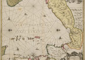
Tabula Asiae XI
Finely colored example of Munster’s map of the Indian Ocean and contiguous regions, extending from Southeast Asia to the Ganges River (including its mouth) and north to the Himalayas (top of map).
The map is based upon the writings of Ptolemy and does not show a passage to the Pacific. Munster’s Geographia was a cartographic landmark, including not only Ptolemaic maps, but also a number of landmark modern maps, including the first separate maps of the 4 continents, the first map of England and the earliest obtainable map of Scandinavia.
The inset picture shows an Indian tiger and birds.
The beautiful colored verso was probably cut by the famous 16th century woodcutter Hans Holbein.
Sebastian Münster
Münster is generally regarded as one of the most important map makers of the 16th Century . Munster was a linguist and mathematician, who initially taught Hebrew in Heidelberg. He issued his first mapping of Germany in 1529, after which he issued a call geographical information about Germany to scholars throughout the country. The response was better than hoped for, and included substantial foreign material, which supplied him with up to date, if not necessarily accurate maps for the issuance of his Geographia in 1540.