


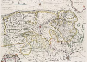
Fiandra parte Occidentale
by
Vincenzo Maria Coronelli
Detail
Date of first edition: 1690
Date of this map: 1690
Dimensions (not including margins): 60,3 x 44,5 cm
Dimensions (including margins): 68,5 x 48,5 cm
Condition: reasonalbe/good. Sharp copper engraving on strong paper and wide margins. Horizontal centre fold as published. Stains on top and bottom margin not affecting map. A few small repairs at edge of paper.
Condition rating: A/B
Verso: text in Italian
From: Universal Geography Course
Unless otherwise specifically stated on this map page, we charge the following expedition costs in euro (unfortunatelly, gone up with Covid, but still too low in reality!):
– Benelux: 40 euro
– Rest of Europe: 60 euro
– Rest of the World: 100 euro
This item is sold
Related items
You may also be interested in:

Algiers – Algerii Saracenaorum Urbis Fortissimae…
by
Georg Braun and Frans Hogenberg
Price (without VAT, possibly to be added): €800,00 / $888,00 / £712,00

Veere – Vere
by
Ludovico Guicciardini
Price (without VAT, possibly to be added): €420,00 / $466,20 / £373,80

Lucca
by
Georg Braun and Frans Hogenberg
Price (without VAT, possibly to be added): €700,00 / $777,00 / £623,00

Jan Mayen – Insulae Johannis Mayen Cum universe situ Sinuum et Promontariorum
by
Joan Blaeu, Johannes Janssonius
Rare Spanish edition
Vincenzo Maria Coronelli
Vincenzo Maria Coronelli, born in 1650, was a cosmographer and mathematician. He was regarded as one of the best known and most talented Italian cartographers.
Coronelli’s cartographic production is based on 500 maps. He became famous for his extraordinary construction of two globes, a celestial and a terrestrial one, with a diameter of 4 m. He was subsequently called to the court of Louis XIV.
This large map depicts northwestern part of Flanders, from North Sea, extends through the northern region of France to the cities of Douai and Vieux-Conde located at the bottom of the map. Showing settlements, administrative division, place names, roads, buildings, forests, rivers and canals. Relief shown pictorially.