
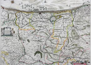
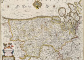
Flandriae Teutonicae pars Orientalior
Cartouche with army of putti
Detail
Date of first edition: 1631 (in Appendix Theatri A. Ortelii et Atlantis G. Mercatoris)
Date of this map: 1641 – 1642
Dimensions (not including margins): 38,5 x 50,5 cm
Condition: good. Sharp copper engraving printed on strong paper. Age-toning at centre fold. Verso split reinforced. Old hand coloured. Wide margins.
Condition rating: A-B
Verso: text in German in Gothic font: “Das Orientalische Theil Flammisch Flandern. (p. 23)
References: Van der Krogt 2,3202:2
From: Toonneel der Steden van ‘s Konings NederlandenJoan and Cornelis Bleau. Van der Krogt 2:231
In stock
Flandriae Teutonicae pars Orientalior
This map shows the coastline of the Duchy of Flanders and a part of Zeeland.
This map forms a duo with Pars Flandriae Teutonicae Occidentalior by Willem Blaeu.
Related items
You may also be interested in:

The Eastern Hemisphere – Hemisphaerium Orbis Antiqui

Chart of the Gulf of Finland

Jan Mayen – Insulae Johannis Mayen Cum universe situ Sinuum et Promontariorum
Rare Spanish edition

Cuzco (Inca capital)
Rare first edition (block destroyed by fire)