
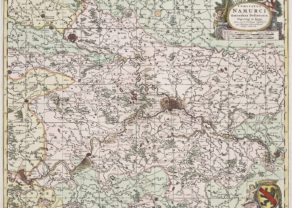
Namur – Namurcum
Detail
Date of first edition: 1579
Date of this map: 1598
Dimensions (not including margins): 38 x 51 cm
Condition: excellent. Sharp copper engraving printed on strong paper. Centre fold is as published. Old hand coloured. Wide margins.
Condition rating: A
Verso: text in French
References: Van den Broecke 68; Van der Krogt 3, 3340:31; Karrow 74/1.1.
From: Theatrum Orbis Terrarum, first published 1579, this edition 1598, Antwerpen, printed by Plantin.
In stock
The Duchy of Namur
This fine map centered on Namur is richly embellished with forests, cities, mountains. This map is based on a manuscript map drawn by Jacques Surhon in 1555, which was suppressed for security reasons. In 1579, when Antwerp became independent for a brief period of time, Ortelius was able to use the manuscript map to create this copper plate. The map is adorned with an elaborate strapwork title cartouche, a compass rose, and a secondary cartouche containing the coat of arms of the region and the privilege imprint.
The city of Charleroi was then situated in the Duchy. On the map it is named Le Charnoÿ, located in the West.
Related items
-
Namur (duchy) – Comitatus Namurici
by Nicolaes VisscherPrice (without VAT, possibly to be added): €275,00 / $305,25 / £244,75 -
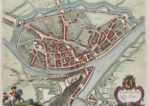
Namur – Namurcum
by Joan BlaeuPrice (without VAT, possibly to be added): €860,00 / $954,60 / £765,40At the confluence of Sambre and Meuse
-
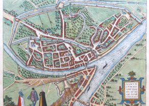
Namur – Namurcum, Elegantissima ad Mosae…
by Georg Braun and Frans HogenbergPrice (without VAT, possibly to be added): €700,00 / $777,00 / £623,00
You may also be interested in:

Algiers – Algerii Saracenaorum Urbis Fortissimae…

Scotland – Nova Scotia
A nice map of Scotland

Bristol – Brightstowe, Vulgo; Quondam Venta, Florentissimum
