

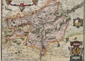
Namur – Namurcum, Elegantissima ad Mosae…
ON HOLD
Detail
Date of first edition: 1581
Date of this map: 1599
Dimensions (not including margins): 33 x 47 cm
Dimensions (including margins): 40,7 x 54,2 cm
Condition: Very good. Copper engraving on strong paper and wide margins. Centre fold as published. Original colouring.
Condition rating: A+
Verso: text in Latin
Map references: Van der Krogt 4, 2948; Fauser, 9475; Taschen, Braun and Hogenberg, p.241
From: Civitates Orbis Terrarum,, Liber tertius
In stock
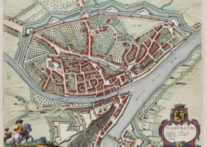
Namur commented by Braun
“The council for the whole county is held here. The people of this city are very experienced in warfare. The princes have a great liking for this city and French is spoken here, albeit in a rather garbled fashion.”
Cartouche: Namur, a very fair city on the River
Full title: Namurcum, Elegantissima ad Mosae Flume Civitas.
Taschen on Namur
This engraving of Namur shows a bird’s-eye view of the city from the south. It offers a clear overview of the topographical setting of the hilly city, which in the 16th century belonged to the House of Habsburg. On the roccky spur high above the Meuse lie a set of modest fortifications. In the 17th century these were expanded into a mighty citadel. Nevertheless, in 1692 the French, under Sébastien Le Prestre Marquis de Vauban’s command, were able to capture the city, fortress and citadel after a siege lasting just a few weeks.
Related items
-
Namur – Namurcum
by Abraham OrteliusPrice (without VAT, possibly to be added): €800,00 / $888,00 / £712,00 -
Namur – Namurcum
by Joan BlaeuPrice (without VAT, possibly to be added): €860,00 / $954,60 / £765,40At the confluence of Sambre and Meuse
-
Liège – Leodium
by Georg Braun and Frans HogenbergPrice (without VAT, possibly to be added): €850,00 / $943,50 / £756,50
You may also be interested in:

San Adrian (Navarre) – La Sierra de Sant Adrian en Biscaia

Map of the Moon – Tabula Selenographica in qua Lunarium
The unique and famous first comparative chart of the Moon (with double competing nomenclature) from which the names of many lunar features have been derived.

Michiel de Ruyter, a super collection by Stoopendaal
Maybe the greatest admiral of all times

China, Tartary and Japan
The first modern map of China printed in Europe