


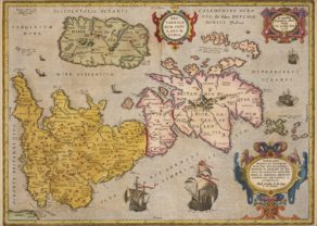
British Isles (with progeny of kings) – Angliae et Hiberniae Accurata Descriptio by Ortelius/Vrients, 1608
Rare and magnificent
Detail
Date of first map: 1606
Date of this map: 1608
Dimensions (without margins): 45,6 x 59,5 cm
Dimensions (including margins): 43,5 x 57,5 cm
Condition: Good copper engraving. Centre fold as published. Strong print and clear image. Cut on neat line with professionally reinforced margins for protective reason.
Condition rating: A+
Verso: text in Italian: L’Anglia Cioe, Inghilterra’
Map References: R.W. Shirley (1991) Early Printed Maps of the British Isles 1477-1650, Antique Atlas Publications, p. 112-113; A. Kelly “Maps of the British Isles, England and Wales, and Ireland”, p. 221-238, in Van den Broecke, van der Krogt & Meurer (eds.) “Abraham Ortelius and the First Atlas”; Van den Broecke, 17.
From:Theatrum Orbis Terrarum
In stock
Angliae et Hiberniae
A rare early map of England and Ireland (and part of Scotland) in perfect condition. Full title in a small cartouche middle top: ‘ANGLIAE ET HIBERNIAE | ACCVRATA DESCRIPTIO, | VETERIBVS ET RECENTIORIBVS | NOMINIBVS ILLVSTRATA: | ET AD D. GVLIEL. CAMDENI BRITANIAM ACCOMODATA’
Bottom centre imprerssum of the editor: ‘Ioannes Baptista Vrints … excuus. Antverpiae’.
Engraver or printer probably was Franz Hogenberg.
Bottom left a catalogue of 52 shires with their characteristics in 10 columns, split over a full and a half size list.
Top right the progeny of English kings from William the Conqueror (1066) up to James I (1603), including a dedication to the last. Many ships, sea gods holding coats of arms and animals in the seas.
From: ” Theatrum Urbis Terrarum, this edition with Italian text (only 300 copies printed!). This map was only published in the Theatrum between 1606 and 1612.
Van Den Broecke mentions that there are 3 states of the map:
- 17.1a: Dedication to James 1
- 17.1b A slip is pasted over the dedication to James I, thus removing it. The text on the slip reads “Unum qua ad Dominum Britannia tota redisti, Una tibi ô redeat sic quoque prisca fides”.
- 17.2 Dedication to James I removed and the circle below now reads “1603 Iacobus Magnæ Britanniæ Rex”.
Related items
You may also be interested in:

Bristol – Brightstowe, Vulgo; Quondam Venta, Florentissimum

Veere – Vere

Cuzco (Inca capital)
Rare first edition (block destroyed by fire)

Jan Mayen – Insulae Johannis Mayen Cum universe situ Sinuum et Promontariorum
Rare Spanish edition