
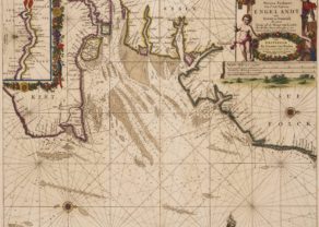
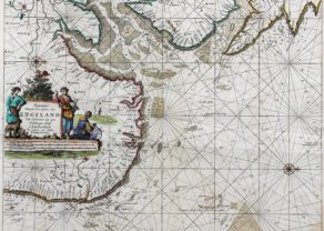
Chart of the British Isles
Rare and exceptional map
Detail
Date of first edition: 1661
Date of this map: 1661
Dimensions (not including margins): 44 x 51 cm
Condition: Excellent condition. Strong, clear print on clean and strong paper. Sufficient margins. Central fold, as issued. Beautifully hand coloured (possibly later date).
Condition rating: A+
Verso: blank
This item is sold
Van Loon commented by Burden:
Joannes van Loon (1611 – 1686) was an accomplished mathematician and astronomer. His first cartographic involvements were with Theunis Jacobsz during the 1640s. From 1650 he worked with Joannes Janssonius, engraving amongst other worksthe plates for his Celestial Atlas by Cellarius, 1660.
In 1661 he published his first work with his brother, Gillis; the ‘Zee Atlas’ contained thirty-five maps. In 1666 the plates were Jan Jansson van Waesberge, with whom he then co-published the atlas. This edition was expanded to forty-seven maps, and by 1676 there were fifty.”
The British Isles by van Loon
The full title of this map is “Pascaerte van Engeland, Schotland, Yerlant en een gedeelte van Franckryk, alles op syn behoorlycke cours veerheyt en breete geleyt, medewat diepte, droogte en ancker gront men op jder plaets heeft, int licht gebracht. t`Amsterdam, Door Iohannes van Loon, Plaetsnyder en Zee-caert-maecker.”
This is the eighth chart in the Klaer Lichtende Noort-Ster Ofte Zee-Atlas (1661), published by Jan van Loon (c.1620-1686). It also has four rectangular insets of harbours in France and England in the lower right quarter: Hable Neuf, Hampton, Londen and Pleimuyen.
“Hable neuf” of new port relates to Paris (as old port). Both cities are on the River Seine. Hable neuf lies at its mouth. Its current name is Le Havre.
Title: Pascaerte van Engeland, Schotland, Yerlant en…
Related items
-
Thames estuary
by Johannes van KeulenPrice (without VAT, possibly to be added): €900,00 / $999,00 / £801,00Inset map: Paskaertje van de Rivier van Londen van Gravesendt, en’t N. Blockhous tot Londen
-
English coast, Hull to Yarnmouth
by Johannes van KeulenPrice (without VAT, possibly to be added): €750,00 / $832,50 / £667,50Charting at its best
You may also be interested in:

Algiers – Algerii Saracenaorum Urbis Fortissimae…

[Untitled] Japan
Very rare: oldest map of Japan, and … based on Polo’s description

Lisbon
