


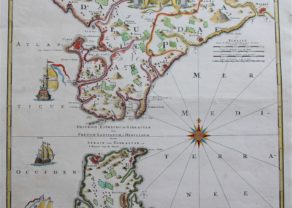
Gibraltar, four views
Detail
Date of first edition: 1733
Date of this map ca. 1733 (mentioned in top heading)
Dimensions of copper plate (without margins): 48,3 x 57,5
Dimensions (including margins): 52,6 x 62 cm
Condition: Very good copper engraving on hard paper. Small professional repair in bottom margin. Centre fold as published.
Condition rating: A+
Verso: blank
In stock
Gibraltar
Gibraltar is a British Overseas Territory located on the southern end of the Iberian Peninsula. In 1704, during the War of the Spanish Succession, a combined Anglo-Dutch fleet, representing the Grand Alliance, captured the town of Gibraltar on behalf of the Archduke Charles of Austria in his campaign to become King of Spain. The occupation of the town by Alliance forces caused the exodus of the population to the surrounding area of the Campo de Gibraltar. As the Alliance’s campaign faltered, the 1713 Treaty of Utrecht was negotiated and ceded control of Gibraltar to Britain to secure Britain’s withdrawal from the war. Unsuccessful attempts by Spanish monarchs to regain Gibraltar were made with the siege of 1727 and again with the Great Siege of Gibraltar (1779 to 1783), during the American War of Independence. Gibraltar became a key base for the Royal Navy and played an important role prior to the Battle of Trafalgar.
Related items
You may also be interested in:

The Eastern Hemisphere – Hemisphaerium Orbis Antiqui

San Adrian (Navarre) – La Sierra de Sant Adrian en Biscaia

Chester – Cestria vulgo Chester, Angliae Civitas

Michiel de Ruyter, a super collection by Stoopendaal
Maybe the greatest admiral of all times
Homann Heirs (Erben) (1724-1780)
Johann Babtiste Homann (1664-1724) was born in Oberkammlach, the Electorate of Bavaria. Although educated at a Jesuit school, and preparing for an ecclesiastical career, he eventually converted to Protestantism and from 1687 worked as a civil law notary in Nuremberg. He soon turned to engraving and cartography; in 1702 he founded his own publishing house. Homann acquired renown as a leading German cartographer, and in 1715 was appointed Imperial Geographer by Emperor Charles VI. Giving such privileges to individuals was an added right that the Holy Roman Emperor enjoyed. In the same year he was also named a member of the Prussian Academy of Sciences in Berlin. Of particular significance to cartography were the imperial printing privileges (Latin: privilegia impressoria). These protected for a time the authors in all scientific fields such as printers, copper engravers, map makers and publishers. They were also very important as a recommendation for potential customers. In 1716 Homann published his masterpiece Grosser Atlas ueber die ganze Welt (Grand Atlas of all the World). Numerous maps were drawn up in cooperation with the engraver Christoph Weigel the Elder, who also published Siebmachers Wappenbuch. Homann died in Nuremberg. He was succeeded by the Homann heirs company, which was in business until 1848. The company was known as Homann Erben, Homanniani Heredes, or Heritiers de Homann abroad.