


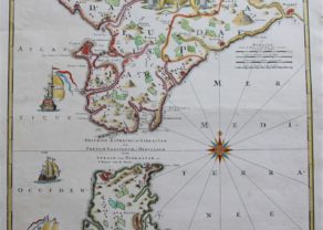
Gibraltar
Detail
Date of this map: 1735
Dimensions (without margins): 53 x 41,5 cm
Dimensions (including margins): 35,6 x 61 cm
Condition: Good copper engraving.Several vertical folds as orginally published. Right margin has been professionally reinforced (at the back.
Condition rating: A+
Verso: blank
From: The Military History of the Late Prince Eugene of Savoy and the Late John Duke of Marlborough &c. Volume I, by Claude du Bosc, London, printed by James Bettenham for Claude du Bosc, engraver at the Golden Head in Charles Street, Covent Garden MDCCXXXVI
In stock
Du Bosc and Gibraltar
The full title of the map (in cartouche reads as follows): “Plan of the town and fortifications of Gibraltar shewing the new works made since the last siege for the better security of that fortress and the lines the Spaniards have built before it exactly taken on the spot”.
Related items
You may also be interested in:

Achaia, Attica and Gulf of Corinth

San Adrian (Navarre) – La Sierra de Sant Adrian en Biscaia

[Untitled] Japan
Very rare: oldest map of Japan, and … based on Polo’s description
