


London, de Fer
by
Nicolas de Fer
Detail
Date of first edition: 1705
Date of this map: 1705
Engraver: Inselin with a 113-point key
Dimensions (not including margins): 22,5 x 33,5 cm
Condition: Very good. Vivid old colouring. Nicely doubled on 18th century strong paper. Wide margins.
Condition rating: Aphere Royale.
Verso: blanc
Map reference: Howego: 44. State 2
From: A La Sphere Royale
Price (without VAT, possibly to be added): €500,00 (FYI +/- $555,00 / £445,00)
Unless otherwise specifically stated on this map page, we charge the following expedition costs in euro (unfortunatelly, gone up with Covid, but still too low in reality!):
– Benelux: 40 euro
– Rest of Europe: 60 euro
– Rest of the World: 100 euro
In stock
Original title: Plan des Villes de Londres et de Westminter et de leurs Faubourgs (…)
Related items
-

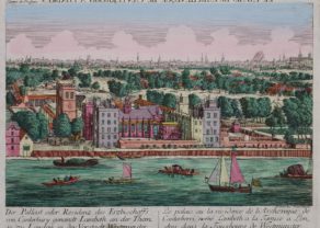
Lambeth Palace – Der Pallast oder Residenz des Erzbischoffs von Canterbury ganandt Lambeth, an der Themse zu London. . .
by Académie Impériale (Augsburg)Price (without VAT, possibly to be added): €650,00 / $721,50 / £578,50Rare in this condition
-
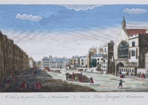
Westminster Palace – Vüe du Palais Episcopal de Westminster
by N.N.Price (without VAT, possibly to be added): €700,00 / $777,00 / £623,00Extremely rare
You may also be interested in:

Portrait Abraham Ortelius, by Galle
by
Abraham Ortelius, Philip Galle
Price (without VAT, possibly to be added): €800,00 / $888,00 / £712,00

Veere – Vere
by
Ludovico Guicciardini
Price (without VAT, possibly to be added): €420,00 / $466,20 / £373,80

Scotland – Nova Scotia
by
Willem and Joan Blaeu
Price (without VAT, possibly to be added): €1 000,00 / $1 110,00 / £890,00
A nice map of Scotland

Lisbon
by
Georg Braun and Frans Hogenberg
Price (without VAT, possibly to be added): €1 300,00 / $1 443,00 / £1 157,00