
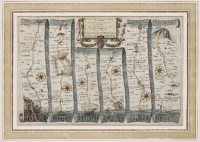
London to St Davids (second part, starting at Abingdon)
by
John Ogilby
A hiking map
Detail
Date of first edition: 1776
Date of this map: 1776
Dimensions (not including margins): 27 x 36,5 cm
Condition: Very good. Copper engraving on strong paper and wide margins. Old coloured. Centre fold as published. Small tear in bottom of centre fold (only on the paper, not on the map) professionally restored at back.
Condition rating: A
Verso: blanc
From: Britannia Atlas
Price (without VAT, possibly to be added): €300,00 (FYI +/- $333,00 / £267,00)
Unless otherwise specifically stated on this map page, we charge the following expedition costs in euro (unfortunatelly, gone up with Covid, but still too low in reality!):
– Benelux: 40 euro
– Rest of Europe: 60 euro
– Rest of the World: 100 euro
In stock
Related items
You may also be interested in:

Lisbon
by
Georg Braun and Frans Hogenberg
Price (without VAT, possibly to be added): €1 300,00 / $1 443,00 / £1 157,00

Map of the Moon – Tabula Selenographica in qua Lunarium
by
Johann Gabriel Doppelmayr
Price (without VAT, possibly to be added): €3 500,00 / $3 885,00 / £3 115,00
The unique and famous first comparative chart of the Moon (with double competing nomenclature) from which the names of many lunar features have been derived.

San Adrian (Navarre) – La Sierra de Sant Adrian en Biscaia
by
Georg Braun and Frans Hogenberg
Price (without VAT, possibly to be added): €700,00 / $777,00 / £623,00

Luxembourg, Duchy
by
Abraham Ortelius
Price (without VAT, possibly to be added): €750,00 / $832,50 / £667,50
Hiking in the 18th century
Road maps were practically unknown in the 15th to 17th century: maps showed mountains and rivers, but never roads.
The first old road maps focused on the internal land connections and did not provide a general geographic identification of an area. A old road map indicated how locations A and B are connected, but the larger space is not necessarily known (cfr. A metro map of London). One understands how to get from A to B, but the general context is missing.. The best known road map is the Peutinger set of four maps issued to Ortelius. It presents quite a naive representation of the world of antiquity.
Scotsman John Ogilby (1600-1676) was appointed in 1674 as His Majesty’s cosmographer and Geographic Printer. He made his Britannia Atlas (dedicated to King Charles II, see his arms above middle) for a refreshing novelty in cartography with a road atlas. Previously, after all, only mountains and waterways were indicated, but never roads.
The atlas, published in 1675, covers England and Wales and contains 100 maps showing the main roads. A total of 7,500 road miles covered. Details for another 21 maps had already been recorded by a surveyor, but they were only published in 1679 by William Morgan, step-grandson Ogilby. The scale of the maps is uniform (1: 63 360): each inch displays 1 mile or 1760 yards. Even more, it was the first atlas to use the Statute Mile of 1760 yards.
This map presents the second part of the connection between London and St Davids, starting at Abingdon (near Oxford) over Faringdon, Lechlade, Fairwood, Barnsley, Glocester to St Davids (southwest Wales). It is map no. 31 of the first atlas. Each road map depicts a route in the form of 6 or 7 vertical strips with a compass rose showing orientation; additionally, miles, furlongs, towns, churches, inns, forges, windmills, rivers, hills and even gallows are shown.
Ogilby is buried in St. Bride’s, a church designed by Christopher Wren and located on Fleet Street.
The advertised price for subscribers in early 1672 for the atlas was 4 to 5 pounds! The Road Atlas was a huge success with four editions in the first two years. In 1794 a 24th and final edition was published in 266 pages … among many pirate publications.