


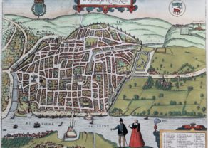
Saintes (Charente-Maritime)
Detail
Date of first edition: 1596
Date of this map: 1596
Dimensions (not including margins): 36 x 45,8 cm
Dimensions (including margins): 42,6 x 55 cm
Condition: Very good. Strong paper with minor browning. Wide margins. Centre fold as published. Original colouring.
Condition rating: A
Verso: text in Latin
Map references: Van der Krogt 4, 3810, Taschen Br. Hog, p. 371
From: Civitates Orbis Terrarum, Vol. V, Urbium Praecipuarum Mundi Theatrum, Liber Quintum; Van der Krogt 41:1-3, page 17
In stock
Saintes commented by Braun
COMMENTARY BY BRAUN: “Saintes is the capital of the Santones, situated on the Charente: this city was called Mediolanum Santonum by Ptolemy; Mediolanum was a bishoric from the time of the Apostles onwards. The ancient walls and the other antiquities show that Mediolanum was formerly the capital of the Santones; the Romans subsequently changed the name and gave it another name, after the people who lived there.”
Taschen on Saintes
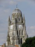
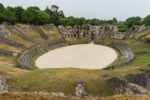
This plate is shown in a bird’s-eye view from the east, from the modern-day Faubourg des Dames, offering a clear overview of the city of Saintes and the surrounding countryside. The city, which had 15,000 inhabitants even in Roman times, is constructed in the manner of a fortress. Various ruins testify to its Roman past, including a triumphal arch of Germanicus, thermal baths and an amphitheatre (Q). In the city centre stands the cathedral of Saint-Pierre (I). On the hill to the left, outside the city walls, rises the pelgrimage church of Saint-Eutrope, today only partly intact, which formes one of the stations along the Way of St James. Also famous is the Abbaye aux Dames (5) on the opposite bank of the Charente, a former nunnery with its abbey of Sainte-Marie-des-Dames. During the Wars of Religion in France, Saintes became a cultural and religious centre of the Huguenots. Today the town near the west coast of France has 25,000 inhabitants.
Encore
Full title (cartouche in French): En ce pourtrait de la vile et cité de Saintes, Chef de la Comté de Saintonge en Guienne,…
The map was drawn by Joris Hoefnagel.
In Roman times, Saintes was known as Mediolanum Santonum, and during much of its history, the name of the city was spelled Xaintes and Xainctes. Primarily built on the left bank of the Charente, Saintes became the first Roman capital of Aquitaine.

Related items
You may also be interested in:

Portrait Abraham Ortelius, by Galle

Lucca

Jan Mayen – Insulae Johannis Mayen Cum universe situ Sinuum et Promontariorum
Rare Spanish edition
