


")
")
Stockholm – Accurate Carte der Uplandischen Scheren…
Rare map
Detail
Date of first edition: 1720
Date of this map: 1720
Dimensions (copper plate, not including margins): 50 x 58,2 cm
Dimensions (including margins): 57 x 65 cm
Condition: Very good condition. Centre fold as published, horizontal fold, original coloring closed opening at centre. Strong image with lovely original colors and wide margins. Also with horizontal centre fold as published.
Condition rate: A+
Verso: blank
In stock
Homann
Johann Babtiste Homann (1664-1724), Nuremberg, was born in Oberkammlach, the Electorate of Bavaria. Although educated at a Jesuit school, and preparing for an ecclesiastical career, he eventually converted to Protestantism and from 1687 worked as a civil law notary in Nuremberg. He soon turned to engraving and cartography; in 1702 he founded his own publishing house. Homann acquired renown as a leading German cartographer, and in 1715 was appointed Imperial Geographer by Emperor Charles VI. Giving such privileges to individuals was an added right that the Holy Roman Emperor enjoyed. In the same year he was also named a member of the Prussian Academy of Sciences in Berlin. Of particular significance to cartography were the imperial printing privileges (Latin: privilegia impressoria). These protected for a time the authors in all scientific fields such as printers, copper engravers, map makers and publishers. They were also very important as a recommendation for potential customers. In 1716 Homann published his masterpiece Grosser Atlas ueber die ganze Welt (Grand Atlas of all the World). Numerous maps were drawn up in cooperation with the engraver Christoph Weigel the Elder, who also published Siebmachers Wappenbuch. Homann died in Nuremberg. He was succeeded by the Homann heirs company, which was in business until 1848. The company was known as Homann Erben, Homanniani Heredes, or Heritiers de Homann abroad.
This map
Accurate Carte der Uplandischen Scheren – Nuremberg, ca. 1730. Sweden – Stockholm: Accurate map of the Upland skerries with the situation and area around the royal Swedish capital and resident city of Stockholm.
A rare map by Johann Baptist Homann (1663-1724), of Stockholm and its environs. Title and impressum in a cartouche at centre left, ‘Accurate Carte der Uplandischen Scheren mit der Situation und Gegend umb die Konigle Schwedifche Haupt und Refidentz Stadt Stockhold edirt von Ioh Bapt Homann Thro Rom Kays Maj Geographo in Nurnberg Cum Privilegio Sac, Caf, Majeftatis’.
With 2 engraved panoramic views of Stockholm: ‘Prospect of the Royal Swedish Residence Castle in Stockholm with the Norder Malm’ and ‘Prospect of the Royal Street in Stockholm with the Syder Malm and Ritterholms Kirch’. Both uncolored.
Related items
-
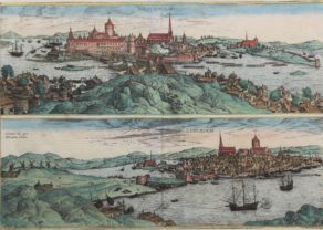
Stockholm
by Georg Braun and Frans HogenbergPrice (without VAT, possibly to be added): €1 950,00 / $2 164,50 / £1 735,50Superb two birds’-eye views (North and South) after Hieronymus Scholäus
-
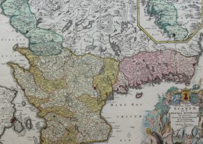
Southern Sweden
by Johann Baptist HomannPrice (without VAT, possibly to be added): €240,00 / $266,40 / £213,60
You may also be interested in:

Scotland – Nova Scotia
A nice map of Scotland

Luxembourg, Duchy

Edinburgh

Map of the Moon – Tabula Selenographica in qua Lunarium
The unique and famous first comparative chart of the Moon (with double competing nomenclature) from which the names of many lunar features have been derived.