


Constantinople – de expurgnatione Constatinopolis
by
Hartmann Schedel
Only forty years before
Detail
Date of first edition: 1493 (Latin edition)
Date of this map: 1493 (Latin edition)
Dimensions of the view: 23 x 23,5 cm
Overall dimensions (including margins): 41,2 x 29 cm
Condition: very good. Sharp woodcut engraving printed on strong paper.
Condition rating: A+
Verso: text in Latin
From: Liber Chronicarum. (= Nuremberg Chronicle). Nürnberg, Koberger, 1493
Unless otherwise specifically stated on this map page, we charge the following expedition costs in euro (unfortunatelly, gone up with Covid, but still too low in reality!):
– Benelux: 40 euro
– Rest of Europe: 60 euro
– Rest of the World: 100 euro
This item is sold
Related items
You may also be interested in:

Jan Mayen – Insulae Johannis Mayen Cum universe situ Sinuum et Promontariorum
by
Joan Blaeu, Johannes Janssonius
Rare Spanish edition

Lucca
by
Georg Braun and Frans Hogenberg
Price (without VAT, possibly to be added): €700,00 / $777,00 / £623,00

Cuzco (Inca capital)
by
Giovanni Battista Ramusio
Price (without VAT, possibly to be added): €850,00 / $943,50 / £756,50
Rare first edition (block destroyed by fire)

Lisbon
by
Georg Braun and Frans Hogenberg
Price (without VAT, possibly to be added): €1 300,00 / $1 443,00 / £1 157,00
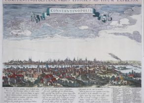
Constantinople: 40 years later
Panoramic view of Constantinople/Istanbul to show the capture of the city by the Turks in 1453. A imaginary view: however the earliest obtainable view of this period.
Page from the richest illustrated Incunable, the famous: Nuremberg Chronicle , published the year that Columbus returned to Europe after discovering America.
The woodblock cutters were Michael Wolgemut, the well-known teacher of Albrecht Dürer, and his stepson Wilhelm Pleydenwurff. Wohlgemut was Albrecht Dürer’s tutor between 1486-90 and recent scholarship has shown, Albrecht Dürer may also have collaborated, since some of the cuts bear a remarkably close resemblance to the Apocalypse illustrations. The printing was carried out under the supervision of the great scholar-printer Anton Koberger, whose printing were famous throughout Europe. The first edition of the Nuremberg Chronicle in July 1493 was in Latin and there was a reprint with German text in December of the same year. Dr. Peter Zahn’s accounting indicates that there were probably 1500 Latin and 1000 German copies printed, or 2500 in all.