


Algarve – Beschrijvinghe der Zee Custen vant Landt va Argarbe
by
Lucas Janszoon Waghenaer
Detail
Date of first edition: 1584
Date of this map: 1586
Dimensions (not including margins): 32,5 x 51 cm
Dimensions (including margins): 39,5 x 54, 5 cm
Condition: Very good. Strong paper and wide margins. Slight age-toning.
Condition rating: A+
From: Spieghel der Zeevaert
Price (without VAT, possibly to be added): €2 250,00 (FYI +/- $2 497,50 / £2 002,50)
Unless otherwise specifically stated on this map page, we charge the following expedition costs in euro (unfortunatelly, gone up with Covid, but still too low in reality!):
– Benelux: 40 euro
– Rest of Europe: 60 euro
– Rest of the World: 100 euro
In stock
Related items

You may also be interested in:

Bristol – Brightstowe, Vulgo; Quondam Venta, Florentissimum
by
Georg Braun and Frans Hogenberg
Price (without VAT, possibly to be added): €900,00 / $999,00 / £801,00

Map of the Moon – Tabula Selenographica in qua Lunarium
by
Johann Gabriel Doppelmayr
Price (without VAT, possibly to be added): €3 500,00 / $3 885,00 / £3 115,00
The unique and famous first comparative chart of the Moon (with double competing nomenclature) from which the names of many lunar features have been derived.

Algiers – Algerii Saracenaorum Urbis Fortissimae…
by
Georg Braun and Frans Hogenberg
Price (without VAT, possibly to be added): €800,00 / $888,00 / £712,00

Chester – Cestria vulgo Chester, Angliae Civitas
by
Georg Braun and Frans Hogenberg
Price (without VAT, possibly to be added): €900,00 / $999,00 / £801,00
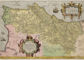
Far origins of the built-up of a world empire
This is a striking full color example of Wagenhaer’s map of the Algarve coastline, extending from just north of Sines in Portugal and the Lagos area to the Rio de Piedras area in Spain.
Reino do Algarve is located on De Groete Sea Oceanus. The name Algarve is etymologically derived from the Arabic Al-Gharb, meaning “west”. Indeed, C. S. Vicente, the most south(western) point of mainland Europe. In nearby Sogres Henry the Navigator (the third son of King John I of Portugal) established a nautical center. During his lifetime (1393-1460) and under his inspiration Portugal laid the essential foundation for her later colonial empire:
• 1415: Ccnquest of Ceuta, a Moorish town;
• from 1418: colonization of Madeira;
• 1427: Gonçalo Velho discovers the Azores;
• 1434: Gil Eanes passes the dangerously considered Cape Bojador;
• 1444: Dinis Dias arrives at River Senegal;
• 1456: Cadamosto reached the Cape Verde Islands.
It is unbelievable that most of these voyages took place half a century before Columbus.
The map shows the two great Portuguese centers: Lagos and Roman Faraon. Silves, capital of the former kingdom Algarve, is not indicated. The border between Algarve and Spain lies in River Guadiana with Aimonte (Ayamonte) on the Spanish side (right) and Castro Marin to the Portuguese side. This castle played an important role in the final phase of the Portuguese “reconquista” of Algarve in 1249/1250.
In the 15th century sea faring was more cost faring: going too far from the coast was considered too dangerous. Hence that the first navigational maps are rather relief sights of the coast than real charts. This is beautifully illustrated by the coast relief above the cartouche.
The cartouche reads as follows: “Beschrijvinghe der Zee Custen vant Landt va Argarbe En ee deel vande Condado, Soe hem tlandt aldaer verthoonten in ghendaente en mesen is — Algarbae orae maritimae, et partis Coridadae accurata descriptio, ac facies navigantibus apparens”