

Iberian Peninsula – Hispaniae Nova Descriptio…
by
Jodocus Hondius, Petrus Kaerius, Jodocus Hondius Jr.
Detail
Date of first edition: 1606 (engraved by Petrus Kaerius)
Date of this map: 1619
Dimensions (not including margins): 37,5 x 51,5 cm
Dimensions (with margins): 46,8 x 57,3 cm
Condition: Very good. Sharp copper engraving on strong paper with wide margins.
Condition rating: A+
Verso: text in French
Map references: Van der Krogt 1, 6000:1A.1
From: Gerardi Mercatoris – Atlas sive Cosmographicae Meditationes de Fabrica Mundi et Fabricati Figura. Amsterdam, J. Hondius, 1619. Van der Krogt 1, 113
Price (without VAT, possibly to be added): €950,00 (FYI +/- $1 054,50 / £845,50)
Unless otherwise specifically stated on this map page, we charge the following expedition costs in euro (unfortunatelly, gone up with Covid, but still too low in reality!):
– Benelux: 40 euro
– Rest of Europe: 60 euro
– Rest of the World: 100 euro
In stock
Related items
You may also be interested in:

Bristol – Brightstowe, Vulgo; Quondam Venta, Florentissimum
by
Georg Braun and Frans Hogenberg
Price (without VAT, possibly to be added): €900,00 / $999,00 / £801,00

Scotland – Nova Scotia
by
Willem and Joan Blaeu
Price (without VAT, possibly to be added): €1 000,00 / $1 110,00 / £890,00
A nice map of Scotland

China, Tartary and Japan
by
Lorenz Fries (after Martin Waldseemüller)
Price (without VAT, possibly to be added): €4 000,00 / $4 440,00 / £3 560,00
The first modern map of China printed in Europe

Portrait Abraham Ortelius, by Galle
by
Abraham Ortelius, Philip Galle
Price (without VAT, possibly to be added): €800,00 / $888,00 / £712,00
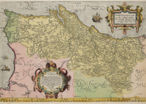
The first and successful map of Iberica in the Hondius catalogue
This superb map of the Iberian Peninsula includes the Balearic Islands. It was engraved by Petrus Kaerius for Jodocus Hondius, who published it (with Cornelis Claesz) in 1606 in his Gerardi Mercatoris… After his death his son Jodocus Honsius II kept on publishing this map; here in his French Atlas of 1619. The successful map was not replaced before 1634.
The map is embellished with elaborate cartouches, sailing ships sea monsters and a compass rose. The sea is engraved in a bold moiré pattern.
Full title: Hispaniae Nova Descriptio, de Integro Multis Inlocis Secundum Hydrographicas, Desc. Emenendata