


Portugal
Detail
Date of first edition: 1606 (Jdocus Hondius and Cornelis Claesz)
Date of this map: 1619 (Jodocus Hondius jr.)
Dimensions (not including margins): 33,5 x 49 cm
Dimensions (including margins): 47 x 56,5 cm
Condition: good. An excellent example with dark print on hand-laid and watermarked paper. Wide margins with some creasing and a short repaired tear, not affecting printed area. Some faint toning and soiling.
Condition rating: A
Verso: text in French
Map reference: Van der Krogt I, 6300:1A
From: Atlas. Van der Krogt I, 1:113, page 112
In stock
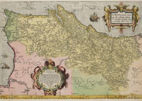
Portugal
A splendid map of Portugal, engraved by Baptista van Doetecum, it is richly embellished with a title, a dedication and a scale cartouches, in addition, with two sailing ships, a compass rose, coat of arms, and a sea monster. Fine hand colouring. Based upon Alvares Secco’s map of 1561. French text on verso.
Full title: Portugalliae que olim Lusitania, novissima et exactissima descriptio Auctore Vernando Alvaro Secco. . .
Related items

You may also be interested in:

San Adrian (Navarre) – La Sierra de Sant Adrian en Biscaia

Michiel de Ruyter, a super collection by Stoopendaal
Maybe the greatest admiral of all times

Scotland – Nova Scotia
A nice map of Scotland

Cuzco (Inca capital)
Rare first edition (block destroyed by fire)