Title page of Germania Inferior
Symbol of the nation
Detail
Date of first edition: 1617
Date of this edition: 1617
Dimensions (not including margins): 23,3 x 36,5 cm
Dimensions (including margins): Condition: Very good. Sharp copper engraving printed on paper. No centre fold. Natural age-toning. Slim margins. Tiny restorations at corners.
Condition rating: A
Verso: blank
From: Petri Kaerii Germania Inferior id est, XVII Provinciarum ejus novae et exactae Tabulae Geographicae, cum Luculentis Singularum descriptionibus additis. à Petro Montano. Amstelodam impensis Pet. Kaerii. 1617; van der Krogt IIIB, 364:01
This item is sold
Title page
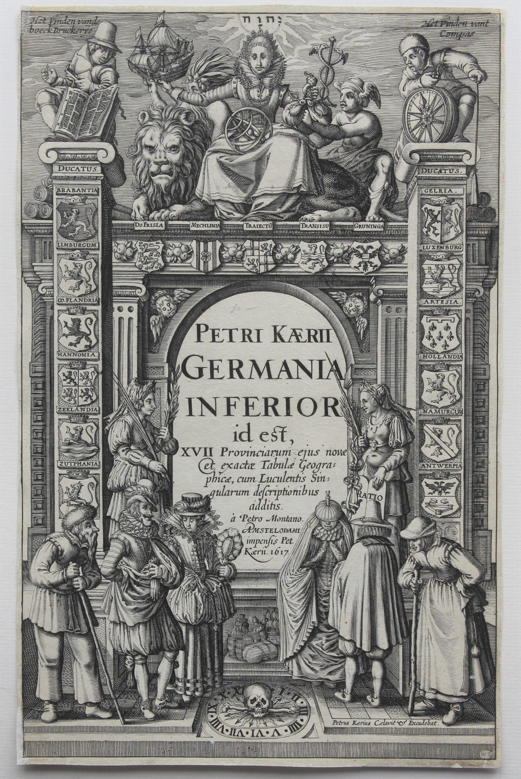
The Leo Belgicus is enthroned at the top of the title page of the atlas Germania Inferior.
A female figure sits on a lion (the Leo Belgicus, emblem of the nation). In her right hand she holds a merchant ship and in her left arm some trading goods, jointly held by the wing-helmeted figure of Mercury, god of trade.
The two figures on the portals are sailors, on the left a man with a navigation book ‘het vindende boeckdruckerije‘, and on the right someone with a compass ‘het vinden vant compas‘.
The portal contains the Latinised coats of arms of the 17 Provinces, including Zutphen. The figures before the portal to the left and right of the text symbolize Peace (with an olive and a palm branch) and the Ratio.
The title page reads: Petri Kaerii Germania Inferior id est, XVII provinciarum ejus novae et exactae Tabulae Geographicae, cum Luculentis Singularum descriptionibus additis. à Petro Montano Amstelodami impensis Pet. Kaerii, 1617.
Six persons symbolize the inhabitants of this region: a high-born couple, a pair from the merchanting class and two peasants. In the middle of them: a stack of barrels and bales refer to trade.
At the bottom a skull (for the finiteness of life) and the sun’s rays. Kaerius published a French and a second Latin version of the atlas; afterwards the copper plates are taken over by Claes Janszoon Visscher, also known by his Latin name Piscator. In 1634 Visscher replaced part of the bottom of the title page and added a self-portrait as a man with a fishing net.

Van der Keere or Kaerius
Van der Keere’s atlas of the Low Countries (Germania Inferior) is one of the landmark regional atlases of the early 17th century, with the maps engraved by himself. His first and only atlas contains the famous Leo Belgicus map.
He would go on to do significant work for John Speed and a number of other map makers in the first part of the 17th century.