

Title page of the Tonneel der Steden van de Vereenighde Nederlanden
Rare original golden colouring
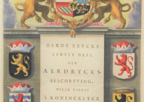
Detail
Date of first edition: 1649
Date of this map: 1649
Dimensions (without margins): 40,7 x 24,7 cm
Dimensions (including margins): 54 x 34,5 cm
Condition: Excellent engraving. Superb golden colouring and wide margins.
Condition rating: A+
Verso: blank
From: Tonneel der Steden van de Vereenighde Nederlanden, Met hare Beschrijvingen, Deel II, Amsterdam, J. Blaeu. 1649. Koeman BI68A
Reference: Shirley; R., Courtiers and Cannibals, Angels and Amazons. The art of decorative cartographic titlepage, Hes & de Graaf Publishers, 2009
In stock
Tonneel der Steden van de Vereenighde Nederlanden by Blaeu
In front of the title page, a fronticpiece was regularly depicted, allegorically indicating which region of the world was included in that volume. This frontispiece was originally the introduction to the Town Atlas of the Netherlands, part II by Joan Blaeu from 1649. The frontispieces are used in many atlases with multiple language versions: that is why the text vignette is glued in the middle to the print.
This gold-colored frontispiece with text vignette comes from Tooneel der Cities of the Vereenighde Nederlanden, Part II of Joan Blaeu from 1649. shows the Seven Provinces:
- the Glory (heerlijkheid) Friesland
- the Duchy of Gelre
- the County Holland
- the Glory Overijssel on the title page “Transisalania”)
- the Heerlijkheid Groningen (at first only De Ommelanden, later also the city of Groningen)
- the Heerlijkheid Utrecht
- the County of Zeeland
The frontispiece also mentions two areas that had lost their independence:
- Zutphania: the county of Zutphen, which was founded as an independent entity in 1046 and ceases to exist in 1591 . After the conquest of Zutphen by Maurits van Nassau, the county was integrated int the Duchy of Gelre, which was already one of the Seven United Provinces.
- Westfrisia: West Friesland is a region in the north of the province of North Holland, enclosed by the Westfriese Omringdijk and located south of the Wieringermeer. The region emerged from the old Westflinge shire. Hoorn, Enkhuizen, Medemblik and Schagen are the most important places in this region. From the 11th century, West Friesland was an autonomous Glory for 300 years, but after Count Floris V conquered West Friesland in 1297 at the Battle of Vronen, West Friesland became part of the county of Holland and from 1840 of the province of North Holland.The heraldic hierarchically higher status of Gelre as a duchy is indicated by its crown which differs from the crown of a Duchy.
Related items
You may also be interested in:

Luxembourg, Duchy

China, Tartary and Japan
The first modern map of China printed in Europe

Chart of the Gulf of Finland

[Untitled] Japan
Very rare: oldest map of Japan, and … based on Polo’s description